Relief means a combination various forms earth's surface. The Eurasia continent is based on large tectonic structures: folded formations, platforms and shields. They are assigned the leading role in shaping the relief of Russia, which occupies the lion's share of the territory of the mainland. Highlands and lowlands are adjacent to mountain ranges, but most of the country is occupied by plains.
Features of the landscape of Russia
Physical relief map of Russia/Wikipedia
The landscape is called the area with general characteristics topography of the earth's surface. Due to its large extent, the territory of the country is characterized by frequent changes in landscape. There is a wide variety of landforms, however, most of the territory has a flat character. The south and east of Russia are represented by mountain complexes. The total length is over 2 million km. The area is approximately 350 thousand km². From west to east, eight main landforms replace each other:
the East European Plain
The territory covers an area of \u200b\u200babout 4 million km², and is. It stretched from the Baltic Sea to the Black and Caspian Seas and from the Vistula River to the Ural Mountains. The plain differs from other zones in the variety of relief. The lowlands alternate with the highlands. The lowest areas are located off the coast of the Caspian Sea. Elevations reach 500 m.
West Siberian Plain
The territory occupies 2.6 million km². Its borders are the Ural Mountains in the west and the Yenisei River in the east. The relief is characterized by uniformity, the maximum height is 200 m. There are many interfluves and river valleys. Part of the land is occupied by swamps.
North Siberian Lowland
The territory extends from the mouth of the Yenisei to the Olenyok River, completely covering Taimyr. It lies in the subsided part of the Siberian platform. Permafrost relief forms dominate, most of the land is swampy. The highest point is 300 m.
Central Siberian Plateau
The territory occupies 3.5 million km². The natural boundaries are the Yenisei River in the west and the Lena River in the east. It lies entirely on the Siberian platform. The region is divided by river valleys. Plateaus are replaced by hilly hills. The highest point is 1701 m.
South Siberian mountains
The area of the territory is 1.5 million km². The borders are the plains Western Siberia and Pacific Ocean. Mountain belts were formed due to tectonic uplift. The highest point is Mount Belukha, 4509 m. The landscape is represented by mountain and alpine meadows.
Central Yakut lowland
The lands stretch from the Lena River to the Vilyuy River. There are many ponds and marshes on the territory. The western part is flat. The average height does not exceed 100 m. The average elevation in the east is 300 m. Hollows and hills are common in the area.
East Siberian Highlands
The area of the territory is 2 million km². Part of it belongs Far East, North-Eastern District of Siberia and Eastern Asia. The relief is mostly represented by mountain ranges. The highest point is Mount Pobeda, 2443 m. Large rivers Yana, Indigirka, Kolyma flow from west to east.
East Siberian Lowland
The territory is located in the northeast of Yakutia. The maximum height is 300 m. The permafrost landscape prevails. The area is predominantly swampy. As a result of the expulsion of glaciers, many mounds have formed.
The geographical location of Russia relative to large landforms
Most of the territories lie on a large Eurasian plate. Kamchatka and the coast of the Magadan region are located on the Sea of Okhotsk plate. Chukchi autonomous region sprawled across the North American Plate. The southern territories of Siberia lie within the Amur lithospheric plate.
A platform is a practically fixed part earth's crust. The East European Plain lies on the Russian Platform. The West Siberian is located on the young West Siberian platform. The Central Siberian Plateau belongs to the Siberian Platform.
The tectonic structure that separates the platforms from each other is called the fold belt. Mountains form within it. Folding in the history of the formation of the relief of Russia:
- Baikal;
- Caledonian;
- Hercynskaya;
- Mesozoic;
- Cenozoic.
Each era ends with the formation of new mountain systems.
Mountain systems of Russia

Mountain Elbrus
Altai
The Siberian ranges were formed during the Baikal and Caledonian epochs of folding. They are located on the border of Russia, China, Mongolia and Kazakhstan. The relief is divided into high and mid-mountain. The hilly surface occupies a third of all land. The height of the ridges is on average 4000 m. The stone foothills have undergone erosion and weathering. The mid-mountain relief does not exceed 2000 m. The ridges are low, rounded, in places they are separated by river valleys. In the foothill plains, a low-mountain relief stands out, the heights range from 400 to 800 m. There are a lot of hollows in Altai. They occupy entire valleys. Some of them are located at a height, others lie in the lowlands, so they became the bottom of the lake basins.
Ural mountains
Ural is the border between East European and West Siberian Plains. The mountains were formed during the era of the Hercynian folding. The territory is a system of ridges that stretch parallel to each other. The western slopes of the Urals are more gentle. The highest point is Mount Narodnaya, 1895 m. mountain system crosses several. There are many lakes in the mountains, and numerous rivers originate at the foothills.
In the bowels of the mountains there are mineral deposits, in total there are 55 species. Mined here different types ores, gold, coal, platinum. The Ural region is known for its oil and gas deposits. The Ural Mountains are especially famous for their deposits precious stones: emeralds, topazes, diamonds, alexandrites.
Caucasian mountains
The ridges lie between the Black, Azov and Caspian Seas. The mountains were formed in the era of Hercynian folding. It is customary to divide the territory into the Greater and Lesser Caucasus. The highest point of the pen region is Mount Elbrus, 5642 m. Some mountains remain. The Greater Caucasus stretched from Taman to Baku.
The mountain range near the Black Sea is assigned to the Lesser Caucasus. The territory is rich in mineral deposits. Oil and gas have been discovered here, as well as many reserves of hydrocarbons, iron ores, mercury, copper, lead and zinc.
Khibiny
The ridges are located in the Murmansk region, beyond the Arctic Circle. The mountains were formed in the Baikal era of folding. The mountain system has an oval shape. The slopes are covered with snow, river valleys have formed at the foot. Glaciers have influenced the relief. The highest point of the system is Mount Yudychvumchorr, its height is 1200 m. The relief is still being formed. Khibiny are famous for apatite, molybdenum, zirconium and titanium. There is a danger of an avalanche. However, the place is a popular ski resort. Due to the position beyond the Arctic Circle, you can come here to ride all year round.
Large tectonic structures have influenced the diversity of Russia's landforms. On the territory of the country there are lowlands, plateaus, mountains, hills. The predominant form is a plain, to the north there is a general decrease. The highest mountains are located in the south. In the bowels of the mountains there is a whole range of minerals.
If you find an error, please highlight a piece of text and click Ctrl+Enter.
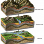
Over time, it changes under the influence of various forces. Places where there were once great mountains are becoming plains, and in some areas there are volcanoes. Scientists are trying to explain why this is happening. And already a lot modern science known.
Reasons for transformations
The relief of the Earth is one of the most interesting mysteries of nature and even history. Because of how the surface of our planet has changed, the life of mankind has also changed. Change occurs under the influence of internal and external forces.
Among all landforms, large and small ones stand out. The largest of them are the continents. It is believed that hundreds of centuries ago, when there was no man yet, our planet had a completely different look. Perhaps there was only one mainland, which eventually broke up into several parts. Then they split up again. And all the continents that exist now appeared.
Another major form was the oceanic depressions. It is believed that earlier there were also fewer oceans, but then there were more of them. Some scientists argue that after hundreds of years new ones will appear. Others say that the water will flood some parts of the land.
The relief of the planet has changed over the centuries. Even despite the fact that a person sometimes greatly harms nature, his activity is not capable of significantly changing the relief. This requires such powerful forces that only nature has. However, a person cannot not only radically transform the relief of the planet, but also stop the changes that nature itself produces. Despite the fact that science has made a big step forward, it is not yet possible to protect all people from earthquakes, volcanic eruptions and much more.
Basic information
The relief of the Earth and the main landforms attract the close attention of many scientists. Among the main varieties are mountains, highlands, shelves and plains.

The shelf is those parts of the earth's surface that are hidden under the water column. Very often they stretch along the coast. The shelf is that type of relief that is found only under water.
Uplands are isolated valleys and even range systems. Much of what is called mountains is actually highlands. For example, Pamir is not a mountain, as many people think. The Tien Shan is also a highland.
Mountains are the most grandiose landforms on the planet. They rise above the land by more than 600 meters. Their peaks are hidden behind the clouds. It happens that in warm countries you can see mountains, the peaks of which are covered with snow. The slopes are usually very steep, but some daredevils dare to climb them. Mountains can form chains.
The plains are stability. The inhabitants of the plains are the least likely to experience changes in relief. They almost do not know what earthquakes are, because such places are considered the most favorable for life. A real plain is the most flat earthly surface.
Internal and external forces
The influence of internal and external forces on the Earth's relief is grandiose. If you study how the surface of the planet has changed over several centuries, you can see how what seemed eternal disappears. It is being replaced by something new. External forces are not able to change the Earth's relief as much as internal ones. Both the first and the second are divided into several types.
internal forces
The internal forces that change the Earth's relief cannot be stopped. But in modern world scientists from different countries they try to predict when and where an earthquake will occur, where a volcanic eruption will occur.

Internal forces include earthquakes, movements, and volcanism.
As a result, all these processes lead to the emergence of new mountains and mountain ranges on land and at the bottom of the ocean. In addition, there are geysers, hot springs, chains of volcanoes, ledges, cracks, depressions, landslides, volcano cones and much more.
Outside forces
External forces are not capable of producing noticeable transformations. However, they should not be overlooked. The shaping of the Earth's relief includes the following: the work of wind and flowing waters, weathering, the melting of glaciers and, of course, the work of people. Although man, as mentioned above, is not yet able to greatly change the face of the planet.

The work of external forces leads to the creation of hills and ravines, hollows, dunes and dunes, river valleys, rubble, sand and much more. Water can destroy even a great mountain very slowly. And those stones that are now easily found on the shore may turn out to be part of a mountain that was once great.
Planet Earth is a grandiose creation in which everything is thought out to the smallest detail. It has changed over the centuries. There have been cardinal transformations of the relief, and all this - under the influence of internal and external forces. In order to better understand the processes taking place on the planet, it is imperative to know about the life that it leads, not paying attention to man.
 Under relief the earth's surface is understood as the totality of all its forms. To depict the relief on a topographic map, horizontal lines, elevations and conventional signs. The image of the relief by contour lines makes it possible to recognize the forms and elements of the relief from the map, to identify their interrelations and to obtain its characteristics. The contour lines and their relative position are transmitted (Fig. 1).
 picture 1
 The terrain is very varied. Most main:
Mountain - a hill on the earth's surface in the form of a dome or cone; depicted as closed contour lines encircling one another (see Fig. 2. a). The slope direction indicators are located with outer side, and they distinguish at point C the top, at points A and B - the soles of the mountain, along the line AC - a gentle slope, and along the line BC a steep slope. If the slope turns from gentle to steep, then it is called a cliff.
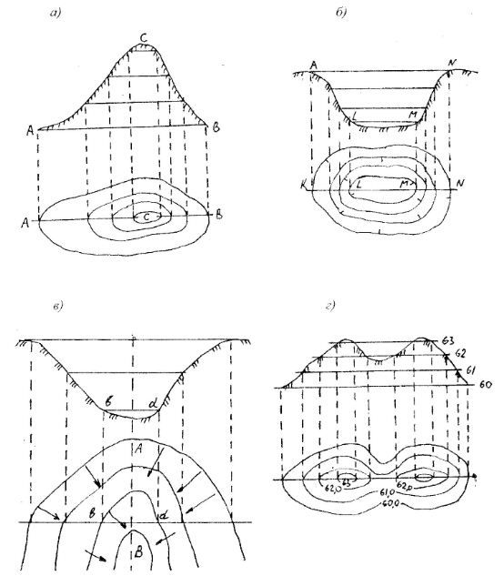 figure 2
 A cliff is a very steep cliff.
Hollow - a recess, closed on all sides; is depicted by the same closed contour lines as the mountain, but the slope direction indicators are turned inward, towards the bottom of the basin. It distinguishes along the lines KL and MN - slopes or sides and LM - the bottom of the basin (Fig. 2, b).
A hill, depression or basin can be identified by the slope indicators - berghstrich (Fig. 2). So, if the berghstrich (short dash) is directed towards outside, then this is a hill, if in the inner - a hollow.
A hollow (Fig. 2, c) is a hollow of a gutter-like shape. It distinguishes slopes along the lines ab and cd and the bottom of the hollow, along which the thalweg line AB runs. The thalweg is usually the bed of the drain. A hollow with wide and gentle slopes is called a valley, and a narrow and deep valley in mountainous areas is called a gorge. Sites located along the slopes of hollows, having the form of a ledge or steps with a horizontal surface, are called terraces.
The contours that reveal the hollow are convexly turned towards the more elevated part of the terrain. A narrow hollow with branches is called a ravine.
The ridge - (spur, ridge) is depicted by a system of elongated U - shaped horizontals (Fig. 1). This is a landform opposite to a hollow.
If a line is drawn through the points where the horizontals have the greatest steepness, then it will separate the slopes (slopes) of opposite directions. This will be the watershed.
saddle - an area that has two opposite sides increase and the other two opposite sides decrease (Fig. 2, d). Point C is the saddle point.
The relief of the terrain and its image on the maps
The terrain very rarely represents flat areas of the earth's surface, more often it consists of many convex or concave irregularities, various in shape and size. These irregularities are commonly referred to as terrain.
Landforms can be positive or convex (mountains, mountain ranges, hills, etc.) and negative or concave (hollows, basins, river valleys, etc.).
Each landform is formed by surfaces - slopes (slopes) various lengths, steepness, height and orientation. Crossing each other at different angles and in different directions, the slopes form various elementary landforms, which can be reduced to the following five typical forms:
Mountain - a piece of the earth's surface, significantly elevated above the surrounding area (500 m or more above sea level). The highest part of the mountain is called the mountain peak. It should be peaked, plateau-shaped and other forms. The upper point of the mountain peak is called the peak, the lower part of the mountain (base) is called the sole, and the slope from the top to the sole is called the slope.
The hill is usually round or oval in shape with gentle slopes and sometimes a weakly pronounced foot, with a relative height of up to 200 m, it is customary to call a hill or a height. Artificially created hills are called mounds.
The hill (mountain, height), dominating the surrounding area, is commonly called the command height.
The vertical distance from any point on the surface of the Earth to the average level of the sea surface (level surface) is commonly called the absolute height.
A vast area of the earth's surface, which is a combination of plateaus, mountain ranges and massifs, sometimes alternating with wide gentle basins, is commonly called highlands. An elevated plain with a flat or wavy, slightly dissected surface, bounded by distinct ledges from neighboring flat spaces, is commonly called a plateau. Usually plateaus are poorly dissected, their central part is a flat, undulating or hilly plain, and the edges have individual peaks, groups of peaks. Sometimes there are plateaus, the surface of which is cut by deep crevices in the central parts. Such highly dissected and highly elevated plateaus are called plateaus.
The mountain range is a large, linearly elongated positive landform with clearly defined slopes intersecting in the upper part.
A line dividing the flow of atmospheric water along two slopes directed to different sides commonly referred to as a watershed.
The sharply pronounced top part of the mountain range is called the ridge. It usually has a sharp jagged shape, and is divided into individual peaks by saddles. In a longitudinal section, the crest of the mountain range is a wavy line, its protruding parts correspond to the peaks. The mountain range in the planned outline has a winding shape with mountain spurs extending to the sides and their smaller branches.
An elongated hill with gentle slopes, gradually turning into a plain, and a not pronounced sole is commonly called a ridge. A small elongated hill with a well-defined sole is commonly called a ridge. Hollow - depression, as a rule, bowl-shaped. It must be closed on all sides or open in one or two directions. Its lower part is called the bottom. Sometimes the bottom of the basin is swampy or occupied by the lake. A small hollow, having a slight depth and a flat bottom, is called a saucer or depression. A hollow of very small dimensions is usually called a pit. Hollow - an elongated depression, descending in one direction and having gentle, usually grassy slopes. The slope of a hollow with a clearly defined upper inflection is usually called a brow, and the line along the bottom, to which the slopes are directed and which connects the lowest points, the deepest parts of the bottom, is called a thalweg. Hollows are often overgrown with shrubs or forests. Their bottom is sometimes swampy.
Hollows, large in size, usually having gentle slopes and a slight slope of the bottom, are called valleys. Rivers flow along the bottom of most of the valleys.
Deep steep erosions formed by temporary streams are called ravines. Οʜᴎ arise on elevated plains, slopes of hills or hollows, composed of loose, easily eroded rocks. Their length can reach 5-10 km, width up to 50 m, and depth 30 m or more. The steepness of the slopes of ravines depends on the composition of the soil and often reaches 45 - 50 ° or more. Under the constant action of melt and rain water, they rapidly increase. Over time, after reaching the water-resistant layer, the ravine stops growing in depth, its slopes become more gentle, overgrown with grass and it turns into a beam. Beam - ϶ᴛᴏ dry or with a temporary watercourse valley. Its bottom is gently concave, slopes are convex. The length of the beam is from hundreds of meters to 20 - 30 km, the width along the top is usually 100 - 250 m, along the bottom 15 - 30 m, the depth varies from 20 to 50 m. The steepness of the slopes of the beams reaches 10 - 25 °. The slopes and the bottom are usually turfed and often covered with woody vegetation.
A large gully with a wide flat bottom and gently sloping slopes is a kind of dry valley filled occasionally in spring or during floods with water, it is customary to call a dry valley.
Small washouts (the first stage of development of ravines) with steep exposed walls and a narrow, sometimes winding bottom are called gullies.
Horizontal or slightly inclined platforms, various origins on the slopes of mountains, river valleys and on the coasts of lakes and seas, limited by ledges, are called terraces. Οʜᴎ are single or arranged in the form of steps one above the other. The most common are river terraces that develop on the slopes of most river valleys and are remnants of the former bottom.
Deep river valleys with very steep, often steep slopes and a narrow bottom, usually completely occupied by the riverbed, are called canyons: Their depth can reach several tens, and sometimes hundreds of meters. Narrow and deep mountain hollows with steep, in some places sheer, rocky slopes and a narrow winding bottom are called gorges. Unlike the canyon, the bottom of the gorge is somewhat wider and is not completely occupied by the river bed.
Deep and narrow hollows in the mountains, with steep or sometimes overhanging slopes, built entirely of bedrock, are called gorges. Their width is insignificant, and the bottom is completely occupied by the riverbed, which usually has a high flow rate.
A saddle is a depression between the peaks of a mountain range. It is almost always the place where two hollows begin, diverging in opposite directions.
The lowest and most accessible place in the crest of a mountain, ridge or massif is usually called a pass. As a rule, the pass is located in the saddles, less often on the inclined parts of the ridges. The height of the passes depends on the height of the mountain ranges.
Deeply incised and low-lying saddles on both slopes of the same range or between two mountain ranges are called mountain passes.
Landforms - concept and types. Classification and features of the category "Relief forms" 2017, 2018.
Accumulative activity of the wind Accumulative activity of the wind consists in the accumulation of eolian deposits, among which two genetic types are distinguished - eolian sands and eolian loess (table). These deposits in modern era are formed in deserts and on them ... .
The work of ice on the transfer of detrital material. Loose clastic material carried or deposited by ice is called moraine. The moraine includes fragments of the most various sizes: from large boulders (glacial boulders) with scars, polishing to crushed stone, gruss, sand, ... .
Ticket 23 Canada. population and economy. CANADA (Canada), state in North America. It occupies the northern part of the mainland and the islands adjacent to it, including the Canadian Arctic Archipelago, the islands of Newfoundland, Vancouver. It borders with the USA, there is ... .
Relief This is a set of irregularities of the earth's surface. The relief in the drawings can be depicted in color, marks, strokes and contour lines. In geodesy, the method of contour lines is used. A horizontal line is a closed curved line connecting points with the same ....
Landforms are characterized by many indicators - origin, relation to the surface of the earth, isolation and size.
The origin of landforms is determined mainly by two factors - nature and man-made human activities. Thus, all landforms are divided into natural and anthropogenic.
Natural landforms are born as a result of three processes:
- 1) movements of the earth's crust;
- 2) destructive erosion and abrasive activity of the hydrosphere (as well as eolian factors);
- 3) accumulation (accumulation) of precipitation on the surface of the earth.
These processes create the following landforms:
- 1) tectonic - mountain ranges, plains, oceanic depressions; these forms are quite stable and they are disturbed mainly by tectonic processes and seismic phenomena;
- 2) erosive - are formed as a result of erosive activity surface water(ravines, river valleys); these landforms are unstable and change over time;
- 3) accumulative - are created as a result of accumulation of precipitation; these are forms washed in by water (river sediments, river deltas, mudflow cones, etc.) and inspired by the wind (desert dunes, dunes of sea coasts, etc.); forms are not very stable, rather rapidly changing over time.
Anthropogenic landforms. On the present stage In the history of the Earth, the relief of its surface began to change intensively due to man-made human activities. Landforms arise that nature does not create. Anthropogenic forms are formed as a result of the work of mining enterprises, engineering and construction activities, military operations, and the development of land for agriculture.
Anthropogenic landforms include planned land under agricultural and construction works ah, waste heaps from waste rocks during the development of mines, dumps of land during quarrying, excavations and embankments during road construction and etc.
Anthropogenic forms are relatively stable, such as road embankments and cuts, but in most cases are temporary. An example is roadside quarries intended for filling embankments. Upon completion of construction work, these landforms cease to exist due to land leveling.
In relation to the surface of the earth, relief forms are divided into positive, which rise above the ground, and negative, i.e., depressions.
To positive forms reliefs include:
- 1. uplands- a vast upland, consisting of a system of mountain ranges and peaks (for example, the Pamirs).
- 2. mountain range- a low mountain range with gentle slopes and a flat top (for example, the Donetsk Ridge).
- 3. mountain range- an elongated hill with a relative height of more than 200 m and with steep slopes.
- 4. Mountain- an isolated hill with steep slopes, more than 200 m high.
- 5. Plateau - upland plain, vast in area, with flat tops.
- 6. Plateau- an elevated plain, bounded by well-defined, often steep slopes.
- 7. Ridge- a narrow elongated hill with a steepness of slopes of more than 20 ° and flat tops.
- 8. Uval - elongated hill of great length, with gentle slopes and flat tops.
- 9. Hill- an isolated dome-shaped or conical hill with gentle slopes and a height of less than 200 m.
- 10. Kurgan - artificial hill.
- 11. hillock- an isolated dome-shaped hill with a pronounced plantar lithium with a slope steepness of not more than 25 ° and flat tops.
- 12. cone- low elevation of land at the mouth of watercourses, such as rivers, ravines, etc.
negative forms are:
- 1. Basin- lowering of considerable depth with steep slopes; a shallow depression with gentle slopes is called a depression.
- 2. Valley- an elongated depression with a slope in one direction with slopes of various steepness and shape.
- 3. Beam- an elongated depression of considerable length, with turfed gentle slopes on three sides.
- 4. Ravine- an elongated depression with steep and sometimes steep slopes.
- 5. scour- a small, elongated, shallow depression with steep, non-soddy slopes on three sides.
Relief forms by isolation in space divided into open(ravine, excavation) and closed(mountain, embankment).
According to the size of landforms, it is customary to divide into seven types: the smallest, very small, small, medium, large, largest and greatest.
The smallest forms - size in centimeters (sand ripples, furrows in the fields, etc.). These forms are not applied to topographic maps.
Very small shapes- size from tens of centimeters to 1-2 m (hummocks, potholes, small gullies). On large-scale maps, they are indicated by conventional signs.
small forms sometimes called microrelief. These forms take small areas(several square meters and sometimes more) at a height of several meters. These forms are reflected on maps of scales 1:10,000, 1:5000 and larger.
Medium forms(mesorelief) are divided into positive and negative. Positive forms include hills, mounds, barrows, ridges, ledges, terraces of river valleys, sea and lake shores. In plan, they occupy hundreds, thousands and more square meters. Many of them are very long. Negative forms - ravines, beams, sinkholes, hollows.
The mesorelief is clearly depicted on topographic (geomorphological) maps at a scale of 1:50,000 and plays an important role in the design of roads and airfields.
large forms(macrorelief) - in terms of occupies tens, hundreds and less often more than square kilometers with a depth division of 200-2000 m. Such a relief is reflected on maps 1:100,000 and 1:1,000,000. mountain ranges; negative - large valleys, lacustrine depressions such as Ladoga and Onega lakes. The relief of this type allows you to evaluate entire territories when planning the placement of construction projects.
Largest forms relief (mega-relief) occupy tens and hundreds of square kilometers. These are large hills, basins. The difference in elevations can reach 500-4000 m. Due to their size, such forms can be displayed on maps with a scale of at least 1:10,000,000.
The Greatest(planetary) forms - in area it is millions of square kilometers, the difference in elevations is 2500-6500 m, the maximum is 20,000 m. Positive forms are continents, and negative ones are oceanic depressions.
Scales topographic maps are very different and are used in construction depending on the stages of designing objects. In some cases, small-scale maps are needed, and in others, large-scale ones. These can be maps from 1:2000 to 1:1,000,000, large landforms are displayed as contour lines, and small ones - with conventional (typical) signs.