Russian empire - a state that existed from November 1721 to March 1917.
The empire was created after the end of the Northern War with Sweden, when Tsar Peter the Great proclaimed himself emperor, and ended its existence after the February Revolution of 1917 and the last emperor, Nicholas II, resigned his imperial powers and abdicated from the throne.
The population of the vast power at the beginning of 1917 was 178 million people.
The Russian Empire had two capitals: from 1721 to 1728 - St. Petersburg, from 1728 to 1730 - Moscow, from 1730 to 1917 - St. Petersburg again.
The Russian Empire had vast territories: from the Arctic Ocean in the north to the Black Sea in the south, from the Baltic Sea in the west to the Pacific Ocean in the east.
The major cities of the empire were St. Petersburg, Moscow, Warsaw, Odessa, Lodz, Riga, Kyiv, Kharkov, Tiflis (modern Tbilisi), Tashkent, Vilna (modern Vilnius), Saratov, Kazan, Rostov-on-Don, Tula, Astrakhan, Ekaterinoslav (modern Dnepropetrovsk), Baku, Chisinau, Helsingfors (modern Helsinki).
The Russian Empire was divided into provinces, regions and districts.
As of 1914, the Russian Empire was divided into:
a) provinces - Arkhangelsk, Astrakhan, Bessarabia, Vilna, Vitebsk, Vladimir, Vologda, Volyn, Voronezh, Vyatka, Grodno, Yekaterinoslav, Kazan, Kaluga, Kyiv, Kovno, Kostroma, Courland, Kursk, Livonia, Minsk, Mogilev, Moscow, Nizhny Novgorod, Novgorod, Olonets, Orenburg, Oryol, Penza, Perm, Podolsk, Poltava, Pskov, Ryazan, Samara, St. Petersburg, Saratov, Simbirsk, Smolensk, Tauride, Tambov, Tver, Tula, Ufimsk, Kharkiv, Kherson, Kholmsk, Chernihiv, Estonian, Yaroslavl, Volyn, Podolsk, Kyiv, Vilna, Kovno, Grodno, Minsk, Mogilev, Vitebsk, Courland, Livonian, Estonian, Warsaw, Kalisz, Kielce, Lomzhinsk, Lublin, Petrokov, Plock, Radom, Suwalk, Baku, Elizavetpol (Elisavetpol), Kutaisi, Stavropol, Tiflis, Black Sea, Erivan, Yenisei, Irk Utskaya, Tobolskaya, Tomskaya, Abo-Björneborgskaya, Vazaskaya, Vyborgskaya, Kuopioskaya, Nielanskaya (Nyulandskaya), St. Michelskaya, Tavastguskaya (Tavastgusskaya), Uleaborgskaya
b) regions - Batumi, Dagestan, Kars, Kuban, Terek, Amur, Trans-Baikal, Kamchatka, Primorskaya, Sakhalin, Yakut, Akmola, Trans-Caspian, Samarkand, Semipalatinsk, Semirechensk, Syr-Darya, Turgay, Ural, Fergana, Don Army Region;
c) districts - Sukhumi and Zakatalsky.
It would be useful to mention that the Russian Empire in its last years before the collapse included once independent countries - Finland, Poland, Lithuania, Latvia, Estonia.
The Russian Empire was ruled by one royal dynasty - the Romanovs. For 296 years of the existence of the empire, she was ruled by 10 emperors and 4 empresses.
The first Russian Emperor Peter the Great (reigned in the Russian Empire 1721 - 1725) was in this rank for 4 years, although the total time of his reign was 43 years.
Peter the Great set as his goal the transformation of Russia into a civilized country.
Over the last 4 years of his stay on the imperial throne, Peter carried out a number of important reforms.
Peter carried out a reform of public administration, introduced the administrative-territorial division of the Russian Empire into provinces, created a regular army and a powerful navy. Peter also abolished ecclesiastical autonomy and subjugated
imperial church. Even before the formation of the empire, Peter founded St. Petersburg, and in 1712 he moved the capital there from Moscow.
Under Peter, the first newspaper was opened in Russia, many educational institutions for the nobility were opened, and in 1705 the first general education gymnasium was opened. Peter also put things in order in the design of all official documents, forbidding the use of half-names in them (Ivashka, Senka, etc.), forbade forced marriage, taking off his hat and kneeling when the king appeared, and also allowed marital divorces. Under Peter, a whole network of military and naval schools was opened for the children of soldiers, drunkenness was prohibited at feasts and meetings, and state officials were forbidden to wear beards.
To improve the educational level of the nobles, Peter introduced the compulsory study of a foreign language (in those days - French). The role of the boyars was leveled, many boyars from yesterday's semi-literate peasants turned into educated nobles.
Peter the Great forever deprived Sweden of the status of an aggressor country, defeating the Swedish army near Poltava in 1709, led by the Swedish king Charles XII.
During the reign of Peter the Russian Empire annexed to its possessions the territory of modern Lithuania, Latvia and Estonia, as well as the Karelian Isthmus and part of Southern Finland. In addition, Bessarabia and Northern Bukovina (the territory of modern Moldova and Ukraine) were included in Russia.
After the death of Peter, Catherine I ascended the imperial throne.
The Empress did not reign for long, only two years (reigned 1725 - 1727). However, her power was rather weak and was actually in the hands of Alexander Menshikov, Peter's comrade-in-arms. Catherine showed interest only in the fleet. In 1726, the Supreme Privy Council was created, which, under the formal chairmanship of Catherine, ruled the country. During Catherine's time, bureaucracy and embezzlement flourished. Catherine only signed all the papers that were handed over to her by representatives of the Supreme Privy Council. Within the council itself, there was a struggle for power, reforms in the empire were suspended. During the reign of Catherine the First, Russia did not wage any wars.
The next Russian emperor, Peter II, also reigned for a short time, only three years (reigned 1727 - 1730). Peter II became emperor when he was only eleven years old, and he died at the age of fourteen from smallpox. In fact, Peter did not rule the empire, for such a short period he did not even have time to show interest in state affairs. The real power in the country continued to be in the hands of the Supreme Privy Council and Alexander Menshikov. Under this formal ruler, all the undertakings of Peter the Great were leveled. The Russian clergy made attempts to separate from the state, the capital was moved from St. Petersburg to Moscow, the historical capital of the former Moscow principality and the Russian state. The army and navy fell into decay. Corruption and massive theft of money from the state treasury flourished.
The next Russian ruler was Empress Anna (reigned 1730-1740). However, in reality, the country was ruled by her favorite Ernest Biron, the Duke of Courland.
The powers of Anna herself were greatly curtailed. Without the approval of the Supreme Privy Council, the empress could not impose taxes, declare war, spend the state treasury at her own discretion, promote to high ranks above the rank of colonel, and appoint an heir to the throne.
Under Anna, the proper maintenance of the fleet and the construction of new ships were resumed.
It was under Anna that the capital of the empire was returned back to St. Petersburg.
After Anna, Ivan VI became emperor (year of reign 1740) became the youngest emperor in the history of tsarist Russia. He was put on the throne at the age of two months, but Ernest Biron continued to have real power in the empire.
The reign of Ivan VI turned out to be short. Two weeks later there was a palace coup. Biron was removed from power. The baby emperor lasted a little over a year on the throne. During his formal reign, no significant events occurred in the life of the Russian Empire.
And in 1741, Empress Elizabeth (reigned 1741-1762) ascended the Russian throne.
During the time of Elizabeth, Russia returned to the Petrine reforms. The Supreme Privy Council, which for many years replaced the real power of the Russian emperors, was liquidated. The death penalty was abolished. The privileges of the nobility were legislated.
During the reign of Elizabeth, Russia participated in a number of wars. In the Russian-Swedish war (1741 - 1743), Russia again, like Peter the Great once, won a convincing victory over the Swedes, having won a significant part of Finland from them. This was followed by the brilliant Seven Years' War against Prussia (1753-1760), which ended with the capture of Berlin by Russian troops in 1760.
During the time of Elizabeth, the first university was opened in Russia (in Moscow).
However, the empress herself had weaknesses - she often liked to arrange luxurious feasts that pretty much devastated the treasury.
The next Russian emperor, Peter III, reigned for only 186 days (the year of reign was 1762). Peter energetically engaged in state affairs, during his short stay on the throne, he abolished the Office of Secret Affairs, created the State Bank and for the first time introduced paper money into circulation in the Russian Empire. A decree was created forbidding landowners to kill and maim peasants. Peter wanted to reform the Orthodox Church along Protestant lines. The document "Manifesto on the Liberty of the Nobility" was created, which legally fixed the nobility as a privileged class in Russia. Under this king, the nobles were exempted from compulsory military service. All high-ranking nobles exiled during the reign of previous emperors and empresses were released from exile. However, another palace coup prevented this sovereign from continuing to work properly and reign for the benefit of the empire.
Empress Catherine II (reigned 1762 - 1796) comes to the throne.
Catherine II, along with Peter the Great, is considered one of the best empresses, whose efforts contributed to the development of the Russian Empire. Catherine came to power through a palace coup, overthrowing her husband Peter III, who was cold towards her and treated her with undisguised disdain.
The period of Catherine's reign had the saddest consequences for the peasants - they were completely enslaved.
However, under this empress, the Russian Empire significantly pushed its borders to the west. After the division of the Commonwealth, Eastern Poland became part of the Russian Empire. Also included in it and Ukraine.
Catherine liquidated the Zaporozhian Sich.
During the reign of Catherine the Russian Empire victoriously ended the war with the Ottoman Empire, taking Crimea from it. As a result of this war, the Kuban was also included in the Russian Empire.
Under Catherine, there was a mass opening of new gymnasiums throughout Russia. Education became available to all city dwellers, except peasants.
Catherine founded a number of new cities in the empire.
During the time of Catherine, a major uprising took place in the empire under the leadership of
Emelyan Pugacheva - as a result of further enslavement and enslavement of the peasants.
The reign of Paul I, which followed Catherine, did not last long - only five years. Paul introduced brutal cane discipline in the army. Corporal punishment for nobles was brought back. All nobles were required to serve in the army. However, unlike Catherine, Paul improved the position of the peasants. Corvee was limited to only three days a week. The grain tax in kind from the peasants was abolished. The sale of peasants along with the land was prohibited. It was forbidden to separate peasant families during the sale. Fearing the impact of the recent French Revolution, Paul imposed censorship and banned the importation of foreign books.
Pavel died unexpectedly in 1801 from apoplexy.
His successor, Emperor Alexander I (reigned 1801 - 1825) - during his time on the throne, carried out a victorious Patriotic War against Napoleonic France in 1812. During the reign of Alexander, Georgian lands - Megrelia and the Kingdom of Imereti - became part of the Russian Empire.
Also during the reign of Alexander the First, a successful war was waged with the Ottoman Empire (1806-1812), which ended with the annexation of part of Persia (the territory of modern Azerbaijan) to Russia.
As a result of the next Russian-Swedish war (1806-1809), the territory of all of Finland became part of Russia.
The emperor died unexpectedly of typhoid fever in Taganrog in 1825.
One of the most despotic emperors of the Russian Empire, Nicholas the First (reigned 1825-1855), ascends the throne.
On the very first day of the reign of Nicholas in St. Petersburg there was an uprising of the Decembrists. The uprising ended badly for them - artillery was used against them. The leaders of the uprising were imprisoned in the Peter and Paul Fortress in St. Petersburg and soon executed.
In 1826, the Russian army had to defend its distant frontiers from the troops of the Persian Shah who unexpectedly invaded Transcaucasia. The Russo-Persian war lasted two years. At the end of the war, Armenia was taken from Persia.
In 1830, during the reign of Nicholas I, an uprising against the Russian autocracy took place on the territory of Poland and Lithuania. In 1831, the uprising was crushed by Russian regular troops.
Under Nicholas the First, the first railway from St. Petersburg to Tsarskoe Selo was built. And by the end of the period of his reign, the construction of the St. Petersburg-Moscow railway was being completed.
During the time of Nicholas I, the Russian Empire waged another war with the Ottoman Empire. The war ended with the preservation of Crimea as part of Russia, however, the entire Russian navy was removed from the peninsula in accordance with the agreement.
The next emperor - Alexander II (reigned 1855 - 1881) in 1861 completely abolished serfdom. Under this tsar, the Caucasian War was carried out against the detachments of the Chechen highlanders under the leadership of Shamil, the Polish uprising of 1864 was suppressed. Turkestan was annexed (modern Kazakhstan, Uzbekistan, Tajikistan, Kyrgyzstan and Turkmenistan.
Under this emperor, Alaska was sold to America (1867).
Another war with the Ottoman Empire (1877-1878) ended with the liberation of Bulgaria, Serbia and Montenegro from the Ottoman yoke.
Alexander II is the only Russian emperor who died a violent unnatural death. A bomb was thrown at him by Ignaty Grinevetsky, a member of the Narodnaya Volya organization, during his walk along the embankment of the Catherine Canal in St. Petersburg. The emperor died on the same day.
Alexander III becomes the penultimate Russian emperor (reigned 1881 - 1894).
Under this tsar, the industrialization of Russia began. Railways were built throughout the European part of the empire. The telegraph became widespread. Telephone communication was introduced. In large cities (Moscow, St. Petersburg) electrification was carried out. There was a radio.
Under this emperor, Russia did not wage any wars.
The last Russian emperor - Nicholas II (reigned 1894 - 1917) - took the throne at a difficult time for the empire.
In 1905-1906, the Russian Empire had to fight with Japan, which captured the Far Eastern port of Port Arthur.
In the same year, 1905, an armed uprising of the working class took place in the largest cities of the empire, which seriously undermined the foundations of autocracy. The work of the Social Democrats (future communists) led by Vladimir Ulyanov-Lenin was unfolding.
After the revolution of 1905, tsarist power was seriously limited and transferred to the local Dumas.
The First World War, which began in 1914, put an end to the further existence of the Russian Empire. Nicholas was not ready for such a protracted and exhausting war. The Russian army suffered a series of crushing defeats from the troops of Kaiser's Germany. This hastened the collapse of the empire. Desertions from the front became more frequent among the troops. Looting flourished in the rear cities.
The inability of the tsar to cope with the difficulties that arose in the war and inside Russia provoked a domino effect, in which, in two or three months, the huge and once powerful Russian empire was on the verge of collapse. In addition to this, revolutionary sentiment intensified in Petrograd and Moscow.
In February 1917, a provisional government came to power in Petrograd, staging a palace coup and depriving Nicholas II of real power. The last emperor was asked to get out of Petrograd with his family, which Nicholas immediately took advantage of.
On March 3, 1917, at the Pskov station, in the carriage of his imperial train, Nicholas II officially abdicated the throne, deposing the powers of the Russian emperor.
The Russian Empire quietly and peacefully ceased to exist, giving way to the future empire of socialism - the USSR.
The Russian Empire began its existence in 1721, during the reign of Peter I.
Russia became an Empire after the end of the Northern War, the results of which secured new lands for Russia, access to the Baltic Sea, various economic benefits, and other privileges. The capital of the Russian Empire was the city of St. Petersburg, the creation of Petrovo.
Between 1728 and 1730, Moscow was again the capital of Russia. From 1730 to 1917, St. Petersburg was again the main city. The Russian Empire was a large state, whose lands were immense.
In world history, it was the third state by area that ever existed (the palm in the nomination is held by the Mongolian and British Empires).
The Empire was ruled by the EMPEROR, the monarch, whose power was not limited by anything, except for Christian postulates. In 1905, after the first revolution, the State Duma appeared in the Russian Empire, which limited the power of the monarch.
 On the eve of 1917, Russian agriculture was at its peak. Stolypin's land reform had a beneficial effect in many respects. Between the end of the 19th century and the beginning of the First World War, the grain harvest in Russia doubled.
Russia harvested one-third more grain than Canada, the US and Argentina combined. For example, the harvest of rye from the fields of the Russian Empire in 1894 yielded a crop of 2 billion poods of grain, and in the last pre-war year (1913) - 4 billion.
The Russian Empire during the reign of Nicholas II provided all of Europe with agricultural products.Between 1894 and 1911, cotton production in Russia increased by 388%.
 During the period 1890-1913, the industry of the Russian Empire quadrupled (!!!) its productivity. The income received by the Russian Empire from industrial enterprises was equal to the receipts to the treasury of income from such an industry as agriculture.
Goods produced at Russian enterprises covered 4/5 of the domestic market demand for industrial products. In the four years before the First World War, the number of established joint-stock companies in Russia increased by 132%.
The capital invested in joint-stock companies has quadrupled.
 The main principle of budget planning in autocratic Russia was the absence of deficits. The ministers did not forget about the need to accumulate gold reserves. State revenues in the last years of life
Along with the collapse of the Russian Empire, the majority of the population chose to create independent nation-states. Many of them were never destined to remain sovereign, and they became part of the USSR. Others were incorporated into the Soviet state later. And what was the Russian Empire at the beginning XXcentury?
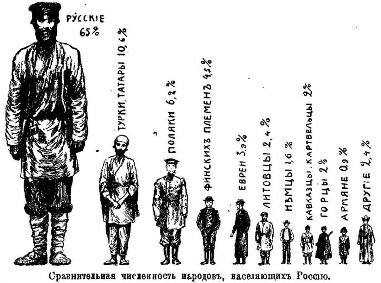
By the end of the 19th century, the territory of the Russian Empire was 22.4 million km2. According to the 1897 census, the population was 128.2 million people, including the population of European Russia - 93.4 million people; The kingdom of Poland - 9.5 million, - 2.6 million, the Caucasus region - 9.3 million, Siberia - 5.8 million, Central Asia - 7.7 million people. More than 100 peoples lived; 57% of the population were non-Russian peoples. The territory of the Russian Empire in 1914 was divided into 81 provinces and 20 regions; there were 931 cities. Part of the provinces and regions was united into governor-generals (Warsaw, Irkutsk, Kiev, Moscow, Amur, Steppe, Turkestan and Finland).
By 1914, the length of the territory of the Russian Empire was 4,383.2 versts (4,675.9 km) from north to south and 10,060 versts (10,732.3 km) from east to west. The total length of land and sea borders is 64,909.5 versts (69,245 km), of which land borders accounted for 18,639.5 versts (19,941.5 km), and sea borders accounted for about 46,270 versts (49,360 km). .4 km).
The entire population was considered subjects of the Russian Empire, the male population (from 20 years old) swore allegiance to the emperor. The subjects of the Russian Empire were divided into four classes ("states"): the nobility, the clergy, urban and rural inhabitants. The local population of Kazakhstan, Siberia and a number of other regions stood out in an independent "state" (foreigners). The emblem of the Russian Empire was a double-headed eagle with royal regalia; the state flag - a cloth with white, blue and red horizontal stripes; national anthem - "God Save the Tsar". National language - Russian.
In administrative terms, the Russian Empire by 1914 was divided into 78 provinces, 21 regions and 2 independent districts. The provinces and regions were subdivided into 777 counties and districts, and in Finland - into 51 parishes. Counties, districts and parishes, in turn, were divided into camps, departments and sections (2523 in total), as well as 274 Lensmanships in Finland.
Important in the military-political terms of the territory (capital and border) were united in the viceroyalty and general government. Some cities were separated into special administrative units - townships.
Even before the transformation of the Grand Duchy of Moscow into the Russian Tsardom in 1547, at the beginning of the 16th century, Russian expansion began to go beyond its ethnic territory and began to absorb the following territories (the table does not indicate lands lost before the beginning of the 19th century):
|
Territory |
Date (year) of joining the Russian Empire |
Data |
|
Western Armenia (Asia Minor) |
The territory was ceded in 1917-1918 |
|
|
Eastern Galicia, Bukovina (Eastern Europe) |
In 1915 it was ceded, in 1916 it was partially recaptured, in 1917 it was lost |
|
|
Uryankhai region (Southern Siberia) |
Currently part of the Republic of Tuva |
|
|
Franz Josef Land, Emperor Nicholas II Land, New Siberian Islands (Arctic) |
Archipelagos of the Arctic Ocean, fixed as the territory of Russia by a note of the Ministry of Foreign Affairs |
|
|
Northern Iran (Middle East) |
Lost as a result of revolutionary events and the Civil War in Russia. Currently owned by the State of Iran |
|
|
Concession in Tianjin |
Lost in 1920. At present, the city of central subordination of the People's Republic of China |
|
|
Kwantung Peninsula (Far East) |
Lost as a result of defeat in the Russo-Japanese War of 1904-1905. Currently Liaoning Province, China |
|
|
Badakhshan (Central Asia) |
Currently Gorno-Badakhshan Autonomous District of Tajikistan |
|
|
Concession in Hankou (Wuhan, East Asia) |
Currently Hubei Province, China |
|
|
Transcaspian region (Central Asia) |
Currently owned by Turkmenistan |
|
|
Adjarian and Kars-Childyr sanjaks (Transcaucasia) |
In 1921 they were ceded to Turkey. Currently Adjara Autonomous Region of Georgia; silts of Kars and Ardahan in Turkey |
|
|
Bayazet (Dogubayazit) sanjak (Transcaucasia) |
In the same year, 1878, it was ceded to Turkey following the results of the Berlin Congress. |
|
|
Principality of Bulgaria, Eastern Rumelia, Adrianople Sanjak (Balkans) |
Abolished by the results of the Berlin Congress in 1879. Currently Bulgaria, Marmara region of Turkey |
|
|
Khanate of Kokand (Central Asia) |
Currently Uzbekistan, Kyrgyzstan, Tajikistan |
|
|
Khiva (Khorezm) Khanate (Central Asia) |
Currently Uzbekistan, Turkmenistan |
|
|
including Åland |
Currently Finland, Republic of Karelia, Murmansk, Leningrad regions |
|
|
Tarnopol District of Austria (Eastern Europe) |
Currently Ternopil region of Ukraine |
|
|
Bialystok District of Prussia (Eastern Europe) |
Currently Podlaskie Voivodeship of Poland |
|
|
Ganja (1804), Karabakh (1805), Sheki (1805), Shirvan (1805), Baku (1806), Quba (1806), Derbent (1806), northern part of the Talysh (1809) khanate (Transcaucasia) |
Vassal khanates of Persia, capture and voluntary entry. Fixed in 1813 by an agreement with Persia following the war. Limited autonomy until 1840s. Currently Azerbaijan, Nagorno-Karabakh Republic |
|
|
Kingdom of Imereti (1810), Megrelian (1803) and Gurian (1804) principalities (Transcaucasia) |
Kingdom and principalities of Western Georgia (since 1774 independent from Turkey). Protectorates and voluntary entry. They were fixed in 1812 by an agreement with Turkey and in 1813 by an agreement with Persia. Self-government until the end of the 1860s. Currently Georgia, the regions of Samegrelo-Upper Svaneti, Guria, Imereti, Samtskhe-Javakheti |
|
|
Minsk, Kiev, Bratslav, eastern parts of the Vilna, Novogrudok, Beresteisky, Volyn and Podolsky voivodeships of the Commonwealth (Eastern Europe) |
Currently Vitebsk, Minsk, Gomel regions of Belarus; Rivne, Khmelnytsky, Zhytomyr, Vinnitsa, Kyiv, Cherkasy, Kirovohrad regions of Ukraine |
|
|
Crimea, Yedisan, Dzhambailuk, Yedishkul, Lesser Nogai Horde (Kuban, Taman) (Northern Black Sea region) |
Khanate (independent from Turkey since 1772) and nomadic Nogai tribal unions. Annexation, secured in 1792 by treaty as a result of the war. Currently Rostov Region, Krasnodar Territory, Republic of Crimea and Sevastopol; Zaporozhye, Kherson, Nikolaev, Odessa regions of Ukraine |
|
|
Kuril Islands (Far East) |
Tribal unions of the Ainu, bringing into Russian citizenship, finally by 1782. Under the treaty of 1855, the South Kuriles in Japan, under the treaty of 1875 - all the islands. Currently, the North Kuril, Kuril and South Kuril urban districts of the Sakhalin Region |
|
|
Chukotka (Far East) |
Currently Chukotka Autonomous Okrug |
|
|
Tarkov shamkhalate (Northern Caucasus) |
Currently the Republic of Dagestan |
|
|
Ossetia (Caucasus) |
Currently Republic of North Ossetia - Alania, Republic of South Ossetia |
|
|
Big and Small Kabarda |
principalities. In 1552-1570, a military alliance with the Russian state, later vassals of Turkey. In 1739-1774, according to the agreement, it was a buffer principality. Since 1774 in Russian citizenship. Currently Stavropol Territory, Kabardino-Balkarian Republic, Chechen Republic |
|
|
Inflyantsky, Mstislavsky, large parts of Polotsk, Vitebsk voivodeships of the Commonwealth (Eastern Europe) |
Currently Vitebsk, Mogilev, Gomel regions of Belarus, Daugavpils region of Latvia, Pskov, Smolensk regions of Russia |
|
|
Kerch, Yenikale, Kinburn (Northern Black Sea region) |
Fortresses, from the Crimean Khanate by agreement. Recognized by Turkey in 1774 by treaty as a result of the war. The Crimean Khanate gained independence from the Ottoman Empire under the auspices of Russia. Currently, the urban district of Kerch of the Republic of Crimea of Russia, Ochakovsky district of the Nikolaev region of Ukraine |
|
|
Ingushetia (Northern Caucasus) |
Currently Republic of Ingushetia |
|
|
Altai (Southern Siberia) |
Currently Altai Territory, Republic of Altai, Novosibirsk, Kemerovo, Tomsk regions of Russia, East Kazakhstan region of Kazakhstan |
|
|
Kymenigord and Neishlot flax - Neishlot, Wilmanstrand and Friedrichsgam (Baltic) |
Len, from Sweden by treaty as a result of the war. Since 1809 in the Russian Grand Duchy of Finland. Currently Leningrad region of Russia, Finland (region of South Karelia) |
|
|
Junior zhuz (Central Asia) |
Currently West Kazakhstan region of Kazakhstan |
|
|
(Kyrgyz land, etc.) (Southern Siberia) |
Currently Republic of Khakassia |
|
|
Novaya Zemlya, Taimyr, Kamchatka, Commander Islands (Arctic, Far East) |
Currently Arkhangelsk Region, Kamchatka, Krasnoyarsk Territory |
What was the Russian Empire on the eve of the World War? Here it is necessary to move away from two myths - the Soviet one, when "tsarist Russia" is shown as a backward country with a downtrodden people, and "Novorossiysk" - the essence of this legend can be expressed by the title of the documentary and journalistic film by the Soviet and Russian director Stanislav Govorukhin "The Russia we lost" (1992). This is an idealized idea of the Russian Empire, which was destroyed by the scoundrels of the Bolsheviks.
The Russian Empire really had a huge potential and could, with an appropriate global, foreign and domestic policy, become a world leader, due to its human reserves (the third largest population on the planet, after China and India), natural resources, creativity and military power. But there were also powerful, deep-seated contradictions, which ultimately destroyed the building of the empire. Were it not for these internal prerequisites, the subversive activities of the Financial International, Western intelligence services, Freemasons, liberals, Socialist-Revolutionaries, nationalists, and other enemies of Russia would not have been successful.
The cornerstones of the Russian Empire were: Orthodoxy, which kept the foundations of Christianity as the basis of the system of upbringing and education; autocracy (autocracy) as the basis of the state system; Russian national spirit, which was the basis for the unity of a vast territory, the core of the empire, at the same time capable of mutually beneficial cooperation with other races, nationalities and religions. But these three foundations were largely undermined: Orthodoxy for the most part became a formality, having lost its fiery spirit of righteousness; The Russian national spirit was eroded by the pressure of Westernism, as a result, the people split - the elite (mostly) adopted European culture, for them Paris and the Cote d'Azur became closer than Ryazan or Pskov, and Marx and Voltaire were more interesting than Pushkin or Lomonosov.
Economic development of Russia of that time causes an ambivalent impression, on the one hand, the successes were high. The empire experienced three economic upsurges - the first was under Alexander II, the second at the end of the 19th and early 20th centuries (it was associated with the stability of the era of Emperor Alexander III and a number of positive innovations such as the introduction of protectionist tariffs and the wine monopoly, a policy of encouraging entrepreneurship, etc.), the third the rise occurred in 1907-1913 and, interestingly, continued even during the First World War and was associated with the activities of P.A. Stolypin and V.N. years). The average annual growth rate in the last period was 5-8%. This rise was even called the "Russian miracle", which happened much earlier than the German or Japanese.

Count Vladimir Nikolayevich Kokovtsov, Russian statesman, chairman of the Council of Ministers of Russia in 1911-1914.
In the 13 pre-war years, the volume of industrial production tripled. Especially rapidly growing new industries - chemical production, oil production, rapid growth was recorded in coal mining. Railways were built: from 1891 to 1916, the Trans-Siberian Railway (Trans-Siberian, or the Great Siberian Way) was built, it connected Moscow and the largest Siberian and Far Eastern industrial centers of the empire, effectively pulling Russia together with an iron belt. It was the longest railway in the world - more than 9 thousand km. The southern branch of the Trans-Siberian was the Chinese Eastern Railway (CER), built in 1897-1903. It belonged to the Russian state and was served by subjects of the empire. Passed through the territory of Manchuria and connected Chita with Vladivostok and Port Arthur.
In the field of light, textile (textiles were exported to China and Persia), food industry, Russia fully provided for itself and exported goods to the foreign market. A more negative situation was in the field of mechanical engineering - Russia itself produced 63% of the equipment and means of production.
The rapid development of Russia caused great concern among Western economists and politicians. In 1913, the Russian Empire came out on top in the world, ahead of the United States, in terms of growth in industrial production. Russia was one of the five strongest economic powers, second only to Great Britain, Germany, catching up with France and the USA. According to French economists, if Russia had maintained the pace of such development, while other powers had maintained the same rate of development, then by the middle of the 20th century the Russian state should have dominated the world in a peaceful, evolutionary way in financial and economic terms, i.e., and politically, becoming the number one superpower.
And this despite the fact that comparing Russia and the British and French colonial empires is somewhat incorrect - Paris and London pumped out funds from the colonies, the subordinate territories developed one-sidedly, only in their own interests. From overseas possessions, the British and French received a huge amount of cheap raw materials. The Russian Empire developed in other conditions - the outskirts were considered Russian and they tried to develop them at the same level as the Great Russian, Little Russian provinces. In addition, it is necessary to take into account the natural and climatic conditions of Russia - there is an excellent book by A.P. Parshev about this, “Why Russia is not America.” It is an order of magnitude more difficult to develop a high civilization in such conditions than in Europe, the USA or the countries of South Asia, Latin America and Africa.
We must also take into account the fact that, although the colonies worked for France and England, researchers forget to include the population of Egypt, India, Sudan, Burma and a host of other possessions in gross per capita indicators, take into account their standard of living, welfare, education, etc. factors . And without colonies, the level of development of the "mother countries" really turned out to be high.
A certain danger for Russia was represented by a relatively high financial debt. Although it is also not worth it to “go too far” and assume that the empire was almost an “appendage of the Western countries”. The total volume of foreign capital investment ranged from 9 to 14%, in principle, not much higher than in Western countries. We must take into account the fact that Russia developed according to the capitalist scheme, was not a socialist state, and therefore played the same games as the Western countries. Russia's external debt by 1914 reached 8 billion francs (2.9 billion rubles), and the external debt of the United States reached 3 billion dollars (about 6 billion rubles), the States at that time were in debt, reversing the trend only due to the First World War .
It was believed that borrowing was more profitable, the money went to the development of the country, major infrastructure projects or the stabilization of the financial situation in 1905-1906 (defeat in the war, the beginning of the revolution in the country). By the beginning of the First World War, the gold reserves of the Russian Empire were the largest in the world and amounted to 1 billion 695 million rubles.
The population of the empire was 160 million people and grew rapidly, the birth rate was high - 45.5 children per 1 thousand inhabitants annually. The myth of total illiteracy and low culture of the Russian people at the beginning of the 20th century is also doubtful. Western researchers, speaking of 30% of literate people, mainly took into account graduates of universities, gymnasiums, real schools, and zemstvo schools. Parish schools, which covered a significant part of the population, were not taken seriously in the West, believing that they did not provide “real education”. Again, one must take into account the factor of general illiteracy of the inhabitants of the European colonies, which were legally and in fact part of the European countries. In addition, in 1912, the Russian Empire adopted a law on universal primary education and on primary schools. If not for the war and the collapse of the empire, the empire would have repeated what the Bolsheviks did - illiteracy would have been completely eliminated. Therefore, complete illiteracy persisted only among foreigners (a category of subjects under the law of the Russian Empire, which did not have a derogatory meaning) in a number of areas of the empire, in the North Caucasus, Central Asia, Siberia and the Far North.
In addition, the imperial gymnasiums and real schools (secondary education) provided a level of knowledge that was approximately equal to the volume of programs in most modern universities. And a person who graduated from a higher educational institution in Russia differed for the better in terms of knowledge than most of today's university graduates. The “Silver Years” was experienced by the culture of Russia - successes were noted in poetry, literature, music, science, etc.

Parliamentary monarchy. You need to know that by the beginning of the 20th century Russia was no longer an absolute monarchy, in the full sense of the term. In 1864, during the judicial reform (the Judicial Charter was introduced), the power of the emperor was actually limited. In addition, the country began to introduce zemstvo self-government, which was in charge of issues of improvement, healthcare, education, social protection, etc. The Manifesto of October 17, 1905 and the reforms of 1907 established the regime of a parliamentary constitutional monarchy in the country.
Therefore, the citizens of the empire owned approximately the same amount of rights and freedoms as the inhabitants of other great powers. Western "democracy" of the early 20th century was very different from the modern one. Suffrage was not universal, most of the population did not have this privilege, their rights were limited by age, property, gender, nationality, race, and other qualifications.
Since 1905, all parties have been allowed in Russia, except for those who carried out terrorist activities, which is quite normal. Both the Bolsheviks and the Socialist-Revolutionaries got into the State Duma. Strikes were suppressed in all countries (and are still being suppressed), and often in the West, the actions of the authorities were more stringent. In Russia, preliminary censorship was abolished, which was used by numerous opponents of the regime from liberal Masons to leftists and nationalists. There was only punitive censorship - the publication could be fined or closed for violating the law (such censorship was widespread and existed not only in Russia). Therefore, you need to know that the myth of the “prison of peoples”, where the king is the “chief overseer”, was invented by the Western press and then supported in Soviet historiography.
Foreign policy
Petersburg tried to pursue a peaceful policy. At the two Hague conferences (1899 and 1907), which were convened on the initiative of Russia, they adopted international conventions on the laws and customs of war, included in the set of norms of world humanitarian law.
In 1899, 26 countries participated in it, adopted 3 conventions: 1) On the peaceful solution of international conflicts; 2) On the laws and customs of land warfare; 3) On the application to naval warfare of the beginnings of the Geneva Convention (dated August 10, 1864). At the same time, the use of shells and explosives from balloons and ships, shells with asphyxiating and harmful gases, and explosive bullets were banned.
In 1907, 43 states participated in it, and 13 conventions have already been adopted, including those on the peaceful solution of world clashes, on the limitation of the use of force in the recovery of contractual debt obligations, on the laws and customs of land war, etc.
After the defeat of France in the Franco-Prussian war of 1871-1871, Russia several times kept Germany from a new attack on the French state. Petersburg tried to resolve disputes on the Balkan Peninsula by political and diplomatic means, without bringing matters to a war, even to the detriment of its strategic interests. During the two Balkan wars (1912-1913), due to the peace-loving policy, all the countries of this region, even the Serbs, turned out to be dissatisfied with Russia.
Although society was “infected” with Francophilism and Pan-Slavism, the Russian public did not want a big war in Europe. The nobility and intelligentsia considered Paris the cultural center of the world. They considered it their sacred duty to intercede for the “Slav brothers” or “brothers in faith”, although there were many examples when these “brothers” entered into alliances with Western countries and acted against the interests of Russia.
For a long time, until 1910-1912, Germany was not perceived as an enemy in Russia. They didn’t want to fight the Germans, this war did not benefit Russia, but it could bring a lot of harm (as it happened).
But Paris and London had to push the “Russian giant” against the “Teutons”. The British were afraid of the growth of the navy of the German Empire, German dreadnoughts could seriously change the balance of power in the world. It was the fleet that allowed the “mistress of the seas” to control the vast expanses of the planet and her colonial empire. They had to provoke a conflict between Germany and Russia and, if possible, stay away. Thus, Sir Edward Gray (British Foreign Secretary in 1905-1916) told the French President Poincare: "Russian resources are so great that in the end Germany will be exhausted even without the help of England."
The French were ambivalent about the war, on the one hand, there was no longer any "Napoleonic" militancy, and they did not want to lose the achieved level of well-being (France was the world's cultural and financial center), but they could not forget the shame of 1870-1871 in Paris. The theme of Alsace and Lorraine was regularly raised on the shield. Many politicians openly led the country to war, among them was Raymond Poincaré, who was elected president in 1913. In addition, many did not like to live under the sword of Damocles of Germany, the German Empire provoked the outbreak of conflict several times, and only the position of Russia and Britain restrained the militant impulses of Berlin. I wanted to solve the problem with one blow.
There was great hope for Russia. In Paris, many believed that if the “Russian barbarians” got off the leash, then Germany would be finished. But Russia was quite stable, and neither the Moroccan crises (1905-1906, 1911), nor the mess in the Balkans (1912-1913) shook its peace-loving position.
The peace-loving nature of Russia is also confirmed by the fact that if Germany began to prepare for war and arm heavily, build an increasingly powerful fleet almost immediately after the victory over France in 1871, then Russia only in 1912 adopted a shipbuilding program. And even then it was much more modest than the German or British, in the Baltic the forces of 4 battleships and 4 battlecruisers were only enough to defend their shores. In March 1914 (!) the State Duma adopted a large military program, which provided for an increase in the army and the modernization of weapons, as a result, the Russian army was supposed to surpass the German one. But both programs were to be completed only by 1917.
In September 1913, Paris and St. Petersburg reached a final agreement on cooperation in case of war. France was supposed to start hostilities on the 11th day after the start of mobilization, and Russia - on the 15th. And in November, the French gave a large loan for the construction of railways in the west of the empire. To improve the mobilization capabilities of Russia.
Internal opponents of the Russian Empire
- A significant part of the imperial elite. The February Revolution of 1917 was staged not by the Bolshevik and not by the Socialist-Revolutionaries, but by financiers, industrialists, part of the generals, senior dignitaries, officials, and deputies of the State Duma. It was not Red Commissars and Red Guards who forced Nicholas II to abdicate the throne, but ministers, generals, deputies, and masons of high levels of initiation who were well-to-do and settled in life.
They dreamed of making Russia a "sweet" England or France, their consciousness was shaped by the matrix of Western civilization. Autocracy seemed to them the last obstacle on the way to Western Europe. These were the supporters of the "European choice" of Russia at that time.
- foreign bourgeoisie, mostly Germans and Jews. Many were members of Masonic lodges. Have contacts abroad. They also dreamed of a “European choice” for Russia. They supported the liberal-bourgeois parties - the Octobrists and the Cadets.
- A significant part of the Russian national bourgeoisie. In a significant mass, these were Old Believers (Old Believers). The Old Believers considered the power of the Romanovs antichrist. This power split the church, violated the proper development of Russia, subjected them to persecution, destroyed the institution of patriarchy and carried out the nationalization of the church. Petersburg planted Western abominations in Russia.
- Most of the intelligentsia was based on Westernism, cut off from the people, a terrible mixture of Voltaires, Hegels, Mars and Engels reigned in their heads ... The intelligentsia was fascinated by the West, dreamed of dragging Russia into Western civilization and rooting it there. In fact, the intelligentsia was "anti-people" (despite its high level of education), there were few exceptions like Leo Tolstoy or Leskov, and they could not change the general Western vector of movement. The intelligentsia did not understand, did not accept the Russian civilizational project, therefore, having taken part in kindling the fire of the revolution, they themselves burned down.
- Professional revolutionaries. They were passionaries of all estates and classes, they were united by a thirst for change. They rejected the modern world completely. These people believed that they could create a new world, much better than the previous one, but for this it was necessary to completely destroy the old one. Among them were Russians, Jews, Poles, Georgians, etc. This movement was not united, it consisted of many parties, organizations, factions.
- Jews. This people has become an important factor in the Russian revolution, one should not belittle their importance, but one should not exaggerate either. They made up a significant part of the revolutionaries of all stripes. Moreover, it should be noted that these were not Jews in the traditional sense of the word. For the most part, these were "converts", "outcasts" of their tribe, those who did not find themselves in the traditional life of Jewish shtetls. Although they enjoyed connections among relatives, including those abroad.
- Nationalists. Polish, Finnish, Jewish, Georgian, Armenian, Azerbaijani, Ukrainian and other nationalists became a powerful factor in the collapse of the empire, on which the Western powers staked.
At the beginning of the XIX century. there was an official consolidation of the boundaries of Russian possessions in North America and northern Europe. The St. Petersburg Conventions of 1824 defined the borders with American () and English possessions. The Americans undertook not to settle north of 54 ° 40 "N on the coast, and the Russians - to the south. The border of Russian and British possessions ran along the coast from 54 ° N to 60 ° N at a distance of 10 miles from the edge of the ocean taking into account all the bends of the coast.The St. Petersburg Russian-Swedish Convention of 1826 established the Russian-Norwegian border.
Academic expeditions of V. M. Severgin and A. I. Sherer in 1802-1804. to the north-west of Russia, to Belarus, the Baltic states and were devoted mainly to mineralogical research.
The period of geographical discoveries in the inhabited European part of Russia is over. In the 19th century expeditionary research and their scientific generalization were mainly thematic. Of these, one can name the zoning (mainly agricultural) of European Russia into eight latitudinal bands, proposed by E.F. Kankrin in 1834; botanical and geographical zoning of European Russia by R. E. Trautfetter (1851); studies of the natural conditions of the Caspian Seas, the state of fishing and other industries there (1851-1857), carried out by K. M. Baer; the work of N. A. (1855) on the animal world of the Voronezh province, in which he showed deep connections between the animal world and physical and geographical conditions, and also established patterns of distribution of forests and steppes in connection with the nature of the relief and soils; classical soil studies of VV in the zone, begun in 1877; a special expedition led by V.V. Dokuchaev, organized by the Forest Department for a comprehensive study of the nature of the steppes and finding ways to deal with. In this expedition, the stationary research method was used for the first time.
Caucasus
The annexation of the Caucasus to Russia necessitated the exploration of new Russian lands, which were poorly studied. In 1829, the Caucasian expedition of the Academy of Sciences, led by A. Ya. Kupfer and E. Kh. Lenz, explored the Rocky Range in the Greater Caucasus, determined the exact heights of many mountain peaks of the Caucasus. In 1844-1865. the natural conditions of the Caucasus were studied by G. V. Abikh. He studied in detail the orography and geology of the Bolshoy and Dagestan, the Colchis lowland, and compiled the first general orographic scheme of the Caucasus.
Ural
The description of the Middle and Southern Urals, made in 1825-1836, is among the works that developed the geographical idea of the Urals. A. Ya. Kupfer, E. K. Hoffman, G. P. Gelmersen; the publication of "The Natural History of the Orenburg Territory" by E. A. Eversman (1840), which gives a comprehensive description of the nature of this territory with a well-founded natural division; Expedition of the Russian Geographical Society to the Northern and Polar Urals (E.K. Gofman, V.G. Bragin), during which the Konstantinov Kamen peak was discovered, the Pai-Khoi ridge was discovered and explored, an inventory was compiled that served as the basis for mapping the studied part of the Urals . A notable event was the journey in 1829 of the outstanding German naturalist A. Humboldt to the Urals, Rudny Altai and to the shores of the Caspian Sea.
Siberia
In the 19th century continued exploration of Siberia, many areas of which were studied very poorly. In Altai, in the 1st half of the century, the sources of the river were discovered. Katun, explored (1825-1836, A. A. Bunge, F. V. Gebler), the Chulyshman and Abakan rivers (1840-1845, P. A. Chikhachev). During his travels, P. A. Chikhachev carried out physical-geographical and geological studies.
In 1843-1844. A. F. Middendorf collected extensive material on orography, geology, climate, and the organic world of Eastern Siberia and the Far East, for the first time information was obtained about the nature of Taimyr, the Stanovoy Range. Based on travel materials, A.F. Middendorf wrote in 1860-1878. published "Journey to the North and East of Siberia" - one of the best examples of systematic reports on the nature of the studied territories. This work gives a description of all the main natural components, as well as the population, shows the features of the relief of Central Siberia, the peculiarity of its climate, presents the results of the first scientific study of permafrost, and gives the zoogeographic division of Siberia.
In 1853-1855. R. K. Maak and A. K. Zondhagen investigated the geology and life of the population of the Central Yakut Plain, the Central Siberian Plateau, the Vilyui Plateau, and surveyed the river.
In 1855-1862. The Siberian expedition of the Russian Geographical Society carried out topographic surveys, astronomical determinations, geological and other studies in the south of Eastern Siberia.
A large amount of research was carried out in the second half of the century in the mountains of the south of Eastern Siberia. In 1858, L. E. Schwartz carried out geographical research in the Sayans. During them, the topographer Kryzhin carried out a topographic survey. In 1863-1866. research in Eastern Siberia and the Far East was carried out by P. A. Kropotkin, who paid special attention to the relief and. He explored the rivers Oka, Amur, Ussuri, ranges, discovered the Patom Highlands. The Khamar-Daban ridge, the coasts, the Angara region, the Selenga basin, were explored by A. L. Chekanovsky (1869-1875), I. D. Chersky (1872-1882). In addition, A. L. Chekanovsky explored the basins of the Nizhnyaya Tunguska and Olenyok rivers, and I. D. Chersky studied the upper reaches of the Lower Tunguska. Geographical, geological and botanical survey of the Eastern Sayan was carried out during the Sayan expedition N. P. Bobyr, L. A. Yachevsky, Ya. P. Prein. The study of Sayanskaya in 1903 was continued by V. L. Popov. In 1910, he also carried out a geographical study of the border strip between Russia and China from Altai to Kyakhta.
In 1891-1892. during his last expedition, I. D. Chersky explored the Nerskoye Plateau, discovered three high mountain ranges Tas-Kystabyt, Ulakhan-Chistai and Tomuskhai behind the Verkhoyansk Range.

Far East
Research continued on Sakhalin, the Kuril Islands and the seas adjacent to them. In 1805, I. F. Kruzenshtern explored the eastern and northern shores of Sakhalin and the northern Kuril Islands, and in 1811, V. M. Golovnin made an inventory of the middle and southern parts of the Kuril ridge. In 1849, G. I. Nevelskoy confirmed and proved the navigability of the Amur mouth for large ships. In 1850-1853. G. I. Nevelsky and others continued research, Sakhalin, adjacent parts of the mainland. In 1860-1867. Sakhalin was explored by F.B., P.P. Glen, G.W. Shebunin. In 1852-1853. N. K. Boshnyak investigated and described the basins of the Amgun and Tym rivers, the Everon and Chukchagirskoye lakes, the Bureinsky Range, and the Khadzhi Bay (Sovetskaya Gavan).
In 1842-1845. A.F. Middendorf and V.V. Vaganov explored the Shantar Islands.
In the 50-60s. 19th century coastal parts of Primorye were explored: in 1853 -1855. I. S. Unkovsky discovered the bays of Posyet and Olga; in 1860-1867 V. Babkin surveyed the northern coast of the Sea of Japan and Peter the Great Bay. The Lower Amur and the northern part of the Sikhote-Alin were explored in 1850-1853. G. I. Nevelsky, N. K. Boshnyak, D. I. Orlov and others; in 1860-1867 - A. Budischev. In 1858, M. Venyukov explored the Ussuri River. In 1863-1866. and Ussuri were studied by P.A. Kropotkin. In 1867-1869. made a major trip to the Ussuri region. He carried out comprehensive studies of the nature of the basins of the Ussuri and Suchan rivers, crossed the Sikhote-Alin ridge.
middle Asia
As individual parts and Central Asia were annexed to the Russian Empire, and sometimes even anticipating it, Russian geographers, biologists and other scientists investigated and studied their nature. In 1820-1836. the organic world of Mugodzhar, the Common Syrt and the Ustyurt plateau was studied by E. A. Eversman. In 1825-1836. conducted a description of the eastern coast of the Caspian Sea, the Mangystau and Bolshoy Balkhan ridges, the Krasnovodsk plateau G. S. Karelin and I. Blaramberg. In 1837-1842. AI Shrenk studied East Kazakhstan.
In 1840-1845. the Balkhash-Alakol basin was discovered (A.I. Shrenk, T.F. Nifantiev). From 1852 to 1863 T.F. Nifantyev conducted the first surveys of lakes, Zaisan. In 1848-1849. A. I. Butakov carried out the first survey, discovered a number of islands, Chernyshev Bay.
Valuable scientific results, especially in the field of biogeography, were brought by the 1857 expedition of I. G. Borshov and N. A. Severtsov to Mugodzhary, the Emba River basin, and the Bolshie Barsuki sands. In 1865, I. G. Borshchov continued research on the vegetation and natural conditions of the Aral-Caspian region. Steppes and deserts are considered by him as natural geographical complexes and mutual relations between relief, moisture, soils and vegetation are analyzed.
Since the 1840s studies of the highlands of Central Asia began. In 1840-1845. A.A. Leman and Ya.P. Yakovlev discovered the Turkestan and Zeravshan ranges. In 1856-1857. P.P. Semyonov laid the foundation for the scientific study of the Tien Shan. The heyday of research in the mountains of Central Asia falls on the period of the expeditionary leadership of P.P. Semyonov (Semyonov-Tyan-Shansky). In 1860-1867. N. A. Severtsov explored the Kyrgyz and Karatau ridges, discovered the Karzhantau, Pskem and Kakshaal-Too ridges, in 1868-1871. A.P. Fedchenko explored the Tien Shan, Kuhistan, Alay and Zaalay ranges. N. A. Severtsov, A. I. Skassi discovered the Rushansky Range and the Fedchenko Glacier (1877-1879). The conducted research allowed to single out the Pamirs as a separate mountain system.
Research in the desert regions of Central Asia was carried out by N. A. Severtsov (1866-1868) and A. P. Fedchenko in 1868-1871. (Kyzylkum desert), V. A. Obruchev in 1886-1888. (desert of Karakum and ancient valley of Uzboy).
Comprehensive studies of the Aral Sea in 1899-1902. spent .
North and Arctic

At the beginning of the XIX century. the opening of the New Siberian Islands. In 1800-1806. Ya. Sannikov carried out inventories of the islands of Stolbovoy, Faddeevsky, New Siberia. In 1808, Belkov discovered the island, which received the name of its discoverer - Belkovsky. In 1809-1811. visited by the expedition of M. M. Gedenstrom. In 1815, M. Lyakhov discovered the islands of Vasilievsky and Semyonovsky. In 1821-1823. P.F. Anjou and P.I. Ilyin carried out instrumental studies, culminating in the compilation of an accurate map of the New Siberian Islands, explored and described the islands of Semyonovsky, Vasilyevsky, Stolbovoy, the coast between the mouths of the Indigirka and Olenyok rivers, and discovered the East Siberian polynya.
In 1820-1824. F. P. Wrangel, in very difficult natural conditions, traveled through the north of Siberia and the Arctic Ocean, explored and described the coast from the mouth of the Indigirka to the Kolyuchinskaya Bay (Chukotka Peninsula), and predicted the existence.
Research was carried out in Russian possessions in North America: in 1816, O. E. Kotzebue discovered a large bay in the Chukchi Sea off the western coast of Alaska, named after him. In 1818-1819. the eastern coast of the Bering Sea was explored by P.G. Korsakovsky and P.A. Ustyugov, the Alaska Delta-Yukon was discovered. In 1835-1838. the lower and middle reaches of the Yukon were investigated by A. Glazunov and V.I. Malakhov, and in 1842-1843. - Russian naval officer L. A. Zagoskin. He also described the interior of Alaska. In 1829-1835. the coast of Alaska was explored by F.P. Wrangel and D.F. Zarembo. In 1838 A.F. Kashevarov described the northwestern coast of Alaska, and P.F. Kolmakov discovered the Innoko River and the Kuskokuim (Kuskokwim) Range. In 1835-1841. D.F. Zarembo and P. Mitkov completed the discovery of the Alexander Archipelago.
The archipelago has been intensively explored. In 1821-1824. F. P. Litke on the brig Novaya Zemlya explored, described and mapped the western coast of Novaya Zemlya. Attempts to make an inventory and map the eastern coast of Novaya Zemlya were unsuccessful. In 1832-1833. the first inventory of the entire eastern coast of the southern island of Novaya Zemlya was made by P.K. Pakhtusov. In 1834-1835. P.K. Pakhtusov and in 1837-1838. A. K. Tsivolka and S. A. Moiseev described the eastern coast of the North Island up to 74.5 ° N. sh., Matochkin Shar Strait is described in detail, Pakhtusov Island was discovered. The description of the northern part of Novaya Zemlya was made only in 1907-1911. V. A. Rusanov. Expeditions led by I. N. Ivanov in 1826-1829. managed to compile an inventory of the southwestern part of the Kara Sea from the Nos to the mouth of the Ob. The studies carried out made it possible to begin studying the vegetation, fauna and geological structure of Novaya Zemlya (K. M. Baer, 1837). In 1834-1839, especially during a major expedition in 1837, A.I. Shrenk explored the Chesh Bay, the coast of the Kara Sea, the Timan Ridge, the island, the Pai-Khoi Range, the polar Urals. Exploration of this area in 1840-1845. continued A. A. Keyserling, who conducted the survey, explored the Timan Ridge and the Pechora Lowland. Comprehensive studies of the nature of the Taimyr Peninsula, the North Siberian Lowland were carried out in 1842-1845. A. F. Middendorf. In 1847-1850. The Russian Geographical Society organized an expedition to the Northern and Polar Urals, during which the Pai-Khoi Ridge was thoroughly explored.
In 1867, Wrangel Island was discovered, the inventory of the southern coast of which was made by the captain of the American whaling ship T. Long. In 1881, the American explorer R. Berry described the eastern, western and most of the northern coast of the island, and for the first time explored the interior of the island.

In 1901, the Russian icebreaker "" visited, under the command of S. O. Makarov. In 1913-1914. a Russian expedition led by G. Ya. Sedov wintered in the archipelago. At the same time, a group of members of the distressed expedition of G. L. Brusilov visited the place on the ship “St. Anna”, headed by navigator V.I. Albanov. Despite the difficult conditions, when all the energy was directed to the preservation of life, V.I. Albanov proved that the Petermann Land and King Oscar Land, which appeared on the map of J. Payer, do not exist.
In 1878-1879. For two navigations, a Russian-Swedish expedition led by the Swedish scientist N. A. E. on a small sailing and steam vessel “Vega” for the first time passed the Northern Sea Route from west to east. This proved the possibility of navigation along the entire Eurasian Arctic coast.
In 1913, the Northern Hydrographic Expedition led by B. A. Vilkitsky on the icebreaker ships Taimyr and Vaigach, exploring the possibilities of passing north of Taimyr, encountered solid ice and, following their edge to the north, discovered islands called the Earth Emperor Nicholas II (now - Severnaya Zemlya), approximately mapping its eastern, and next year - southern shores, as well as the island of Tsarevich Alexei (now -). The western and northern shores remained completely unknown.
Russian Geographical Society
The Russian Geographical Society (RGO), founded in 1845 (since 1850 - the Imperial Russian Geographical Society - IRGO), has made great contributions to the development of domestic cartography.
In 1881, the American polar explorer J. De Long discovered Jeannette, Henrietta, and Bennett Islands northeast of New Siberia Island. This group of islands was named after its discoverer. In 1885-1886. the study of the Arctic coast between the Lena and Kolyma rivers and the New Siberian Islands was carried out by A. A. Bunge and E. V. Toll.
Already at the beginning of 1852, it published its first twenty-five-verst (1:1,050,000) map of the Pai-Khoi coastal ridge, compiled on the basis of materials from the Ural expedition of the Russian Geographical Society in 1847-1850. For the first time, the Pai-Khoi coastal ridge was depicted on it with great accuracy and detail.
The Geographical Society also published 40-verst maps of the river regions of the Amur, the southern part of the Lena and the Yenisei, and about. Sakhalin on 7 sheets (1891).
Sixteen large expeditions of the IRGS, led by N. M. Przhevalsky, G. N. Potanin, M. V. Pevtsov, G. E. Grumm-Grzhimailo, V. I. Roborovsky, P. K. Kozlov and V. A. Obruchev, made a great contribution to the survey of Central Asia. During these expeditions, 95,473 km were covered and photographed (of which over 30,000 km are accounted for by N. M. Przhevalsky), 363 astronomical points were determined, and the heights of 3,533 points were measured. The position of the main mountain ranges and river systems, as well as the lake basins of Central Asia, was clarified. All this greatly contributed to the creation of a modern physical map of Central Asia.
The heyday of the expeditionary activities of the IRGO falls on 1873-1914, when the Grand Duke Konstantin was at the head of the society, and P.P. Semyonov-Tyan-Shansky was the vice-chairman. During this period, expeditions were organized to Central Asia and other regions of the country; two polar stations have been established. Since the mid 1880s. The expeditionary activity of the society is increasingly specialized in individual branches - glaciology, limnology, geophysics, biogeography, etc.

The IRGS made a great contribution to the study of the country's relief. A hypsometric commission of the IRGO was created to process the leveling and make a hypsometric map. In 1874, the IRGS conducted, under the leadership of A. A. Tillo, the Aral-Caspian leveling: from Karatamak (on the northwestern shore of the Aral Sea) through Ustyurt to the Dead Kultuk Bay of the Caspian Sea, and in 1875 and 1877. Siberian leveling: from the village of Zverinogolovskaya in the Orenburg region to Baikal. The materials of the hypsometric commission were used by A. A. Tillo to compile the “map of European Russia” on a scale of 60 versts per inch (1:2,520,000), published by the Ministry of Railways in 1889. More than 50 thousand elevation marks were used to compile it obtained as a result of leveling. The map made a revolution in the ideas about the structure of the relief of this territory. It presented in a new way the orography of the European part of the country, which has not changed in its main features to the present day, for the first time the Central Russian and Volga Uplands were depicted. In 1894, the Forest Department, under the leadership of A. A. Tillo with the participation of S. N., organized an expedition to study the sources of the main rivers of European Russia, which provided extensive material on relief and hydrography (in particular, on lakes).
The Military Topographic Service, with the active participation of the Imperial Russian Geographical Society, carried out a large number of pioneer reconnaissance surveys in the Far East, Siberia, Kazakhstan and Central Asia, during which maps of many territories were compiled, which were previously "white spots" on the map.
Mapping of the territory in the XIX-beginning of the XX centuries.
Topographic and geodetic works

In 1801-1804. “His Majesty's Own Map Depot” issued the first state multi-sheet (on 107 sheets) map at a scale of 1:840,000, covering almost the entire European Russia and called the “Hundred-sheet Map”. Its content was based mainly on the materials of the General Land Survey.
In 1798-1804. The Russian General Staff, under the leadership of Major General F. F. Steinchel (Steingel), with the extensive use of Swedish-Finnish officers-topographers, carried out a large-scale topographic survey of the so-called Old Finland, i.e., areas annexed to Russia along the Nishtadt (1721) and Abosky (1743) to the world. Survey materials, preserved in the form of a handwritten four-volume atlas, were widely used in the compilation of various maps at the beginning of the 19th century.
After 1809, the topographic services of Russia and Finland were merged. At the same time, the Russian army received a ready-made educational institution for the training of professional topographers - a military school, founded in 1779 in the village of Gappaniemi. On the basis of this school, on March 16, 1812, the Gappanyem Topographic Corps was established, which became the first special military topographic and geodetic educational institution in the Russian Empire.
In 1815, the ranks of the Russian army were replenished with officers-topographers of the General Quartermaster of the Polish Army.
Since 1819, topographic surveys on a scale of 1:21,000 began in Russia, based on triangulation and carried out mainly with the help of a beaker. In 1844 they were replaced by surveys on a scale of 1:42,000.

On January 28, 1822, the Corps of Military Topographers was established at the General Staff of the Russian Army and the Military Topographic Depot. State topographic mapping has become one of the main tasks of military topographers. The remarkable Russian surveyor and cartographer F. F. Schubert was appointed the first director of the Corps of Military Topographers.
In 1816-1852. in Russia, the largest triangulation work for that time was carried out, stretching 25 ° 20 "along the meridian (together with the Scandinavian triangulation).
Under the direction of F. F. Schubert and K. I. Tenner, intensive instrumental and semi-instrumental (route) surveys began, mainly in the western and northwestern provinces of European Russia. Based on the materials of these surveys in the 20-30s. 19th century semi-topographic (semi-topographic) maps were compiled and engraved for the provinces on a scale of 4-5 versts per inch.
In 1821, the military topographic depot began compiling an overview topographic map of European Russia on a scale of 10 versts per inch (1:420,000), which was extremely necessary not only for the military, but also for all civilian departments. The special ten-layout of European Russia is known in the literature as the Schubert Map. Work on the creation of the map continued intermittently until 1839. It was published on 59 sheets and three flaps (or half sheets).
A large amount of work was carried out by the Corps of military topographers in different parts of the country. In 1826-1829. detailed maps were drawn up on a scale of 1:210,000 of the Baku province, the Talysh Khanate, the Karabakh province, the plan of Tiflis, etc.
In 1828-1832. a survey was also made of Wallachia, which became a model of the work of its time, as it was based on a sufficient number of astronomical points. All maps were summarized in an atlas of 1:16,000. The total survey area reached 100,000 sq. m. verst.
From the 30s. geodetic and boundary work began to be carried out on. Geodetic points carried out in 1836-1838. triangulation became the basis for creating accurate topographic maps of the Crimea. Geodetic networks were developed in Smolensk, Moscow, Mogilev, Tver, Novgorod provinces and in other areas.
In 1833, the head of the KVT, General F. F. Schubert, organized an unprecedented chronometric expedition to the Baltic Sea. As a result of the expedition, the longitudes of 18 points were determined, which, together with 22 points related to them trigonometrically, provided a reliable justification for surveying the coast and soundings of the Baltic Sea.

From 1857 to 1862 under the direction and at the expense of the IRGO in the Military Topographic Depot, work was carried out to compile and publish on 12 sheets a general map of European Russia and the Caucasus region on a scale of 40 versts per inch (1: 1,680,000) with an explanatory note. On the advice of V. Ya. Struve, the map was created for the first time in Russia in the Gaussian projection, and Pulkovsky was taken as the initial meridian on it. In 1868, the map was published, and later it was repeatedly reprinted.
In subsequent years, a five-verst map on 55 sheets, a twenty-verst and forty-verst orographic maps of the Caucasus were published.
Among the best cartographic works of the IRGS is the “Map of the Aral Sea and the Khiva Khanate with their environs” compiled by Ya. V. Khanykov (1850). The map was published in French by the Paris Geographical Society and, on the proposal of A. Humboldt, was awarded the Prussian Order of the Red Eagle, 2nd degree.
The Caucasian Military Topographic Department, under the leadership of General I. I. Stebnitsky, conducted reconnaissance in Central Asia along the eastern shore of the Caspian Sea.
In 1867, a cartographic institution was opened at the Military Topographic Department of the General Staff. Together with the private cartographic establishment of A. A. Ilyin, opened in 1859, they were the direct predecessors of modern domestic cartographic factories.
Relief maps occupied a special place among the various products of the Caucasian WTO. A large relief map was completed in 1868 and exhibited at the Paris Exhibition in 1869. This map is made for horizontal distances at a scale of 1:420,000, and for vertical distances at 1:84,000.
The Caucasian Military Topographic Department under the leadership of I. I. Stebnitsky compiled a 20-verst map of the Transcaspian Territory based on astronomical, geodetic and topographic works.

Work was also carried out on topographic and geodetic preparation of the territories of the Far East. So, in 1860, the position of eight points was determined near the western coast of the Sea of Japan, and in 1863, 22 points were determined in Peter the Great Bay.
The expansion of the territory of the Russian Empire was reflected in many maps and atlases published at that time. Such, in particular, is the “General Map of the Russian Empire and the Kingdom of Poland and the Grand Duchy of Finland annexed to it” from the “Geographical Atlas of the Russian Empire, the Kingdom of Poland and the Grand Duchy of Finland” by V. P. Pyadyshev (St. Petersburg, 1834).
Since 1845, one of the main tasks of the Russian military topographic service has been the creation of the Military Topographic Map of Western Russia on a scale of 3 versts per inch. By 1863, 435 sheets of the military topographic map had been published, and by 1917, 517 sheets. On this map, the relief was rendered in strokes.
In 1848-1866. under the leadership of Lieutenant General A. I. Mende, surveys were carried out aimed at creating topographic boundary maps and atlases and descriptions for all provinces of European Russia. During this period, work was carried out on an area of about 345,000 square meters. verst. Tver, Ryazan, Tambov and Vladimir provinces were mapped on a scale of one verst to an inch (1:42,000), Yaroslavl - two versts to an inch (1:84,000), Simbirsk and Nizhny Novgorod - three versts to an inch (1:126,000) and the Penza province - on a scale of eight miles to an inch (1:336,000). Based on the results of the surveys, the IRGO published multi-color topographic boundary atlases of the Tver and Ryazan provinces (1853-1860) on a scale of 2 versts per inch (1:84,000) and a map of the Tver province on a scale of 8 versts per inch (1:336,000).
The surveys of Mende had an undeniable impact on the further improvement of the methods of state mapping. In 1872, the Military Topographic Department of the General Staff began work on updating the three-verst map, which actually led to the creation of a new standard Russian topographic map at a scale of 2 versts in an inch (1:84,000), which was the most detailed source of information about the area used in troops and the national economy until the 30s. 20th century A two-verst military topographic map was published for the Kingdom of Poland, parts of the Crimea and the Caucasus, as well as the Baltic states and areas around Moscow and. It was one of the first Russian topographic maps, on which the relief was depicted by contour lines.
In 1869-1885. a detailed topographic survey of Finland was carried out, which was the beginning of the creation of a state topographic map on a scale of one verst in an inch - the highest achievement of pre-revolutionary military topography in Russia. One-verst maps covered the territory of Poland, the Baltic states, southern Finland, the Crimea, the Caucasus and parts of southern Russia north of Novocherkassk.
By the 60s. 19th century the Special Map of European Russia by F. F. Schubert on a scale of 10 versts in an inch is very outdated. In 1865, the editorial commission appointed captain of the General Staff I.A. works. In 1872, all 152 sheets of the map were completed. The ten-versustka was repeatedly reprinted and partially supplemented; in 1903 it consisted of 167 sheets. This map was widely used not only for military, but also for scientific, practical and cultural purposes.
By the end of the century, the work of the Corps of Military Topographers continued to create new maps for sparsely populated areas, including the Far East and Manchuria. During this time, several reconnaissance detachments traveled more than 12 thousand miles, performing route and eye surveys. According to their results, topographic maps were later compiled on a scale of 2, 3, 5 and 20 versts per inch.
In 1907, a special commission was created at the General Staff to develop a plan for future topographic and geodetic work in European and Asian Russia, chaired by the head of the KVT, General N. D. Artamonov. It was decided to develop a new class 1 triangulation according to a specific program proposed by General I. I. Pomerantsev. The implementation of the KVT program began in 1910. By 1914, the main part of the work had been completed.
By the beginning of the First World War, a large volume of large-scale topographic surveys was completed on the territory of Poland completely, in the south of Russia (the triangle of Chisinau, Galati, Odessa), in the Petrograd and Vyborg provinces partially; on a verst scale in Livonia, Petrograd, Minsk provinces, and partially in Transcaucasia, on the northeastern coast of the Black Sea and in the Crimea; on a two-verst scale - in the north-west of Russia, to the east of the survey sites of half- and verst scales.

The results of topographic surveys of the previous and pre-war years made it possible to compile and publish a large volume of topographic and special military maps: a half-verst map of the Western border area (1:21,000); verst map of the Western border area, Crimea and Transcaucasia (1:42,000); a military topographic two-verst map (1:84,000), a three-verst map (1:126,000) with a relief expressed by strokes; semi-topographic 10-verst map of European Russia (1:420,000); 25-verst military road map of European Russia (1:1,050,000); 40-verst Strategic Map (1:1,680,000); maps of the Caucasus and adjacent foreign states.
In addition to the above maps, the Military Topographic Department of the Main Directorate of the General Staff (GUGSH) prepared maps of Turkestan, Central Asia and the states adjacent to them, Western Siberia, the Far East, as well as maps of the entire Asian Russia.
The corps of military topographers over the 96 years of its existence (1822-1918) carried out a huge amount of astronomical, geodetic and cartographic work: geodetic points were identified - 63,736; astronomical points (in latitude and longitude) - 3900; 46 thousand km of leveling passages were laid; instrumental topographic surveys were carried out on a geodetic basis at various scales over an area of 7,425,319 km2, and semi-instrumental and visual surveys were carried out over an area of 506,247 km2. In 1917, the supply of the Russian army was 6739 nomenclatures of maps of various scales.
In general, by 1917, a huge field survey material had been obtained, a number of remarkable cartographic works had been created, however, the topographic coverage of the territory of Russia was uneven, a significant part of the territory remained topographically unexplored.
Exploration and mapping of the seas and oceans
Russia's achievements in the study of the World Ocean were also significant. One of the important incentives for these studies in the 19th century, as before, was the need to ensure the functioning of Russian overseas possessions in Alaska. To supply these colonies, round-the-world expeditions were regularly equipped, which, starting from the first voyage in 1803-1806. on the ships "Nadezhda" and "Neva" under the leadership of Yu. V. Lisyansky, they made many remarkable geographical discoveries and significantly increased the cartographic knowledge of the World Ocean.
In addition to the hydrographic work carried out almost annually off the coast of Russian America by officers of the Russian Navy, participants in round-the-world expeditions, employees of the Russian-American Company, among which were such brilliant hydrographers and scientists as F. P. Wrangel, A. K. Etolin and M D. Tebenkov, continuously updated their knowledge of the northern part of the Pacific Ocean and improved the navigational charts of these regions. Especially great was the contribution of M. D. Tebenkov, who compiled the most detailed “Atlas of the Northwestern coasts of America from to Cape Corrientes and the Aleutian Islands with the addition of some places on the Northeastern coast of Asia”, published by the St. Petersburg Naval Academy in 1852.

In parallel with the study of the northern part of the Pacific Ocean, Russian hydrographers actively explored the coasts of the Arctic Ocean, thus contributing to the finalization of geographical ideas about the polar regions of Eurasia and laying the foundations for the subsequent development of the Northern Sea Route. Thus, most of the coasts and islands of the Barents and Kara Seas were described and mapped in the 20-30s. 19th century expeditions of F. P. Litke, P. K. Pakhtusov, K. M. Baer and A. K. Tsivolka, who laid the foundations for the physical and geographical study of these seas and the Novaya Zemlya archipelago. To solve the problem of developing transport links of the European Pomorye, expeditions were equipped for a hydrographic inventory of the coast from Kanin Nos to the mouth of the Ob River, the most productive of which were the Pechora expedition of I.N. Ivanov (1824) and the inventory of I.N. Ivanov and I.A. Berezhnykh (1826-1828). The maps compiled by them had a solid astronomical and geodetic justification. Studies of sea coasts and islands in the north of Siberia at the beginning of the 19th century. were largely stimulated by the discoveries of islands in the Novosibirsk archipelago by Russian industrialists, as well as the search for mysterious northern lands (“Sannikov Land”), islands north of the mouth of the Kolyma (“Andreev Land”), etc. In 1808-1810. during the expedition led by M. M. Gedenshtrom and P. Pshenitsyn, who explored the islands of New Siberia, Faddeevsky, Kotelny and the strait between the latter, a map of the Novosibirsk archipelago as a whole was created for the first time, as well as the mainland sea coasts between the mouths of the Yana and Kolyma rivers. For the first time, a detailed geographical description of the islands was made. In the 20s. Yanskaya (1820-1824) under the leadership of P.F. Anzhu and Kolymskaya (1821-1824) - under the leadership of F.P. Wrangel - expeditions were equipped in the same areas. These expeditions carried out on an extended scale the work program of the expedition of M. M. Gedenstrom. They were supposed to survey the banks from the Lena River to the Bering Strait. The main merit of the expedition was the compilation of a more accurate map of the entire continental coast of the Arctic Ocean from the Olenyok River to the Kolyuchinskaya Bay, as well as maps of the Novosibirsk, Lyakhovsky and Bear Islands group. In the eastern part of Wrangel's map, according to local residents, an island was marked with the inscription "Mountains are seen from Cape Yakan in the summer." This island was also depicted on maps in the atlases of I.F. Kruzenshtern (1826) and G.A. Sarychev (1826). In 1867, it was discovered by the American navigator T. Long and in commemoration of the merits of the remarkable Russian polar explorer named after Wrangel. The results of the expeditions of P. F. Anzhu and F. P. Wrangel were summarized in 26 handwritten maps and plans, as well as in scientific reports and works.
Not only scientific, but also of enormous geopolitical significance for Russia were carried out in the middle of the 19th century. G. I. Nevelsky and his followers intensive marine expeditionary research in Okhotsk and. Although the insular position of Sakhalin was known to Russian cartographers from the very beginning of the 18th century, which was reflected in their works, however, the problem of accessibility of the Amur mouth for ships from the south and north was finally and positively resolved only by G. I. Nevelsky. This discovery decisively changed the attitude of the Russian authorities towards the Amur Region and Primorye, showing the enormous potential of these richest regions, provided, as G. I. Nevelsky's studies proved, with end-to-end water communications leading to the Pacific Ocean. These studies themselves were carried out by travelers sometimes at their own peril and risk in confrontation with official government circles. The remarkable expeditions of G. I. Nevelsky paved the way for the return of Russia to the Amur region under the terms of the Aigun Treaty with China (signed on May 28, 1858) and joining the Empire of Primorye (under the terms of the Beijing Treaty between Russia and China, concluded on November 2 (14), 1860 .). The results of geographical research on the Amur and Primorye, as well as changes in the boundaries in the Far East in accordance with the agreements between Russia and China, were declared cartographically on maps of the Amur and Primorye compiled and published as soon as possible.
Russian hydrographs in the XIX century. continued active work on the European seas. After the annexation of Crimea (1783) and the creation of the Russian navy on the Black Sea, detailed hydrographic surveys of the Azov and Black Seas began. Already in 1799, the navigation atlas of I.N. Billings on the northern coast, in 1807 - the atlas of I. M. Budischev on the western part of the Black Sea, and in 1817 - the “General Map of the Black and Azov Seas”. In 1825-1836. under the leadership of E. P. Manganari, on the basis of triangulation, a topographic survey of the entire northern and western seas was carried out, which made it possible to publish the “Atlas of the Black Sea” in 1841.
In the 19th century intensive study of the Caspian Sea continued. In 1826, based on the detailed hydrographic works of 1809-1817, carried out by the expedition of the Admiralty Collegiums under the leadership of A.E. Kolodkin, the “Complete Atlas of the Caspian Sea” was published, which fully met the requirements of the shipping of that time.

In subsequent years, the maps of the atlas were refined by the expeditions of G. G. Basargin (1823-1825) on the western coast, N. N. Muravyov-Karsky (1819-1821), G. S. Karelin (1832, 1834, 1836) and others. on the eastern coast of the Caspian. In 1847, I. I. Zherebtsov described the bay. In 1856, a new hydrographic expedition was sent to the Caspian Sea under the leadership of N.A. Ivashintsov, who over the course of 15 years carried out a systematic survey and description, compiling several plans and 26 maps that covered almost the entire coast of the Caspian Sea.
In the 19th century Intensive work continued to improve the maps of the Baltic and White Seas. An outstanding achievement of Russian hydrography was the “Atlas of the entire Baltic Sea…” compiled by G. A. Sarychev (1812). In 1834-1854. based on the materials of the chronometric expedition of F. F. Schubert, maps were compiled and published for the entire Russian coast of the Baltic Sea.
Significant changes were made to the maps of the White Sea and the northern coast of the Kola Peninsula by the hydrographic works of F. P. Litke (1821-1824) and M. F. Reinecke (1826-1833). Based on the materials of the Reinecke expedition, in 1833 the “Atlas of the White Sea ...” was published, the maps of which were used by navigators until the beginning of the 20th century, and the “Hydrographic description of the northern coast of Russia”, which supplemented this atlas, can be considered as an example of a geographical description of the coasts. The Imperial Academy of Sciences awarded this work to MF Reinecke in 1851 with the full Demidov Prize.
Thematic mapping
Active development of basic (topographic and hydrographic) cartography in the 19th century. created the basis necessary for the formation of special (thematic) mapping. Its intensive development dates back to the 19th-early 20th centuries.
In 1832, the Hydrographic Atlas of the Russian Empire was published by the Main Directorate of Communications. It included general maps on a scale of 20 and 10 versts per inch, detailed maps on a scale of 2 versts per inch, and plans on a scale of 100 fathoms per inch and larger. Hundreds of plans and maps were compiled, which contributed to an increase in the cartographic knowledge of the territories along the routes of the corresponding roads.

Significant cartographic work in the XIX-early XX centuries. carried out by the Ministry of State Property formed in 1837, in which in 1838 the Corps of civilian topographers was established, which carried out mapping of poorly studied and unexplored lands.
An important achievement of domestic cartography was the Marx's Great World Desktop Atlas, published in 1905 (2nd edition, 1909), containing over 200 maps and an index of 130,000 geographical names.
Mapping nature
Geological mapping
In the 19th century intensive cartographic study of the mineral resources of Russia and their exploitation continued, special geognostic (geological) mapping is being developed. At the beginning of the XIX century. many maps of mountain districts were created, plans for factories, salt and oil fields, gold mines, quarries, and mineral springs. The history of exploration and development of minerals in the Altai and Nerchinsk mining districts is reflected in particular detail in the maps.
Numerous maps of mineral deposits, plans of land plots and forest holdings, factories, mines and mines were compiled. An example of a collection of valuable handwritten geological maps is the atlas “Salt Mine Maps” compiled by the Mining Department. The maps of the collection belong mainly to the 20-30s. 19th century Many of the maps in this atlas are much broader in content than ordinary salt mine maps and are, in fact, early examples of geological (petrographic) maps. So, among the maps of G. Vansovich of 1825 there is a Petrographic map of the Bialystok region, Grodno and part of the Vilna province. The “Map of the Pskov and part of the Novgorod provinces” also has a rich geological content: showing rock and salt springs discovered in 1824…”
An extremely rare example of an early map is the “Topographic Map of the Crimean Peninsula…” with the designation of the depth and quality of water in the villages, compiled by A.N. Kozlovsky in 1842 on the cartographic basis of 1817. having different water availability, as well as a table of the number of villages by counties in need of watering.
In 1840-1843. The English geologist R. I. Murchison, together with A. A. Keyserling and N. I. Koksharov, conducted research that for the first time gave a scientific picture of the geological structure of European Russia.
In the 50s. 19th century The first geological maps began to be published in Russia. One of the earliest is the Geognostic Map of the St. Petersburg Province (S. S. Kutorga, 1852). The results of intensive geological research found expression in the Geological Map of European Russia (A.P. Karpinsky, 1893).
The main task of the Geological Committee was the creation of a 10-verst (1:420,000) geological map of European Russia, in connection with which a systematic study of the relief and geological structure of the territory began, in which such prominent geologists as I. V. Mushketov, A. P. Pavlov and others. By 1917, only 20 sheets of this map were published out of the planned 170. Since the 1870s. geological mapping of some regions of Asiatic Russia began.
In 1895, the Atlas of Terrestrial Magnetism was published, compiled by A. A. Tillo.
Forest mapping
One of the earliest handwritten maps of forests is the “Map for Reviewing the State of Forests and the Timber Industry in [European] Russia”, compiled in 1840-1841, as established by M. A. Tsvetkov. The Ministry of State Property carried out major work on mapping state-owned forests, the forest industry and forest-consuming industries, as well as on improving forest accounting and forest cartography. Materials for it were collected by inquiries through local departments of state property, as well as other departments. In the final form in 1842, two maps were drawn up; the first of them is a map of forests, the other was one of the earliest samples of soil-climatic maps, which marked climatic bands and dominant soils in European Russia. A soil-climatic map has not yet been discovered.
The work on mapping the forests of European Russia revealed the unsatisfactory state of the device and mapping and prompted the Scientific Committee of the Ministry of State Property to create a special commission to improve forest mapping and forest accounting. As a result of the work of this commission, detailed instructions and symbols were created for the preparation of forest plans and maps, approved by Tsar Nicholas I. The Ministry of State Property paid special attention to the organization of work on the study and mapping of state lands in Siberia, which became especially widespread after the abolition of serfdom in Russia in 1861, one of the consequences of which was the intensive development of the resettlement movement.
soil mapping
In 1838 a systematic study of soils began in Russia. Mostly on the basis of interrogation information, many handwritten soil maps were compiled. Prominent economic geographer and climatologist Academician K. S. Veselovsky in 1855 compiled and published the first consolidated “Soil Map of European Russia”, which shows eight types of soils: black soil, clay, sand, loam and sandy loam, silt, solonetzes, tundra , swamps. The works of K. S. Veselovsky on climatology and soils of Russia were the starting point for the works on soil cartography of the famous Russian geographer and soil scientist V. V. Dokuchaev, who proposed a truly scientific classification for soils based on the genetic principle, and introduced their comprehensive study taking into account factors soil formation. His book Cartography of Russian Soils, published by the Department of Agriculture and Rural Industry in 1879 as an explanatory text for the Soil Map of European Russia, laid the foundations for modern soil science and soil cartography. Since 1882, V. V. Dokuchaev and his followers (N. M. Sibirtsev, K. D. Glinka, S. S. Neustruev, L. I. Prasolov and others) carried out soil, and in fact complex physical and geographical studies in more than 20 provinces. One of the results of these works was soil maps of provinces (on a scale of 10 versts) and more detailed maps of individual districts. Under the direction of V.V. Dokuchaev, N.M. Sibirtsev, G.I. Tanfilyev and A.R. Ferkhmin compiled and published in 1901 the “Soil Map of European Russia” at a scale of 1:2,520,000.
Socio-economic mapping
Economy Mapping

The development of capitalism in industry and agriculture necessitated a deeper study of the national economy. To this end, in the middle of the XIX century. survey economic maps and atlases begin to be published. The first economic maps of individual provinces (St. Petersburg, Moscow, Yaroslavl, etc.) are being created. The first economic map published in Russia was the “Map of the Industry of European Russia Showing Factories, Factories and Industries, Administrative Places in the Manufactory Section, Major Fairs, Water and Land Communications, Ports, Lighthouses, Customs Houses, Major Quays, Quarantines, etc., 1842” .
A significant cartographic work is the “Economic and Statistical Atlas of European Russia from 16 Maps”, compiled and published in 1851 by the Ministry of State Property, which went through four editions - 1851, 1852, 1857 and 1869. It was the first economic atlas in our country devoted to agriculture. It included the first thematic maps (soil, climatic, agricultural). In the atlas and its text part, an attempt was made to summarize the main features and directions of development of agriculture in Russia in the 50s. 19th century
Of undoubted interest is the handwritten "Statistical Atlas", compiled in the Ministry of Internal Affairs under the direction of N. A. Milyutin in 1850. The Atlas consists of 35 maps and cartograms, reflecting a wide variety of socio-economic parameters. It, apparently, was compiled in parallel with the "Economic and Statistical Atlas" of 1851 and, in comparison with it, provides a lot of new information.
A major achievement of domestic cartography was the publication in 1872 of the Maps of the Most Important Branches of Productivity in European Russia compiled by the Central Statistical Committee (about 1:2,500,000). The publication of this work was facilitated by the improvement in the organization of statistical affairs in Russia, associated with the formation in 1863 of the Central Statistical Committee, headed by the famous Russian geographer, vice-chairman of the Imperial Russian Geographical Society P. P. Semyonov-Tyan-Shansky. The materials collected during the eight years of the existence of the Central Statistical Committee, as well as various sources from other departments, made it possible to create a map that multifacetedly and reliably characterizes the economy of post-reform Russia. The map was an excellent reference tool and valuable material for scientific research. Distinguished by the completeness of content, expressiveness and originality of mapping methods, it is a remarkable monument to the history of Russian cartography and a historical source that has not lost its significance up to the present.
The first capital atlas of industry was the “Statistical Atlas of the Main Branches of the Factory Industry of European Russia” by D. A. Timiryazev (1869-1873). At the same time, maps of the mining industry (the Urals, the Nerchinsk District, etc.), maps of the location of the sugar industry, agriculture, etc., transport and economic charts of cargo flows along railways and waterways were published.
One of the best works of Russian socio-economic cartography of the early 20th century. is the “Commercial and industrial map of European Russia” by V.P. Semyonov-Tyan-Shan scale 1:1,680,000 (1911). This map presented a synthesis of the economic characteristics of many centers and regions.
We should dwell on one more outstanding cartographic work created by the Department of Agriculture of the Main Directorate of Agriculture and Land Management before the First World War. This is an atlas-album "Agricultural trade in Russia" (1914), representing a set of statistical maps of agriculture. This album is interesting as an experience of a kind of “cartographic propaganda” of the potential possibilities of the agricultural economy in Russia to attract new investments from abroad.
Population mapping
P. I. Keppen organized a systematic collection of statistical data on the number and ethnographic characteristics of the Russian population. The result of the work of P. I. Keppen was the “Ethnographic Map of European Russia” on a scale of 75 versts per inch (1:3,150,000), which went through three editions (1851, 1853 and 1855). In 1875, a new large ethnographic map of European Russia was published on a scale of 60 versts per inch (1:2,520,000), compiled by the famous Russian ethnographer, Lieutenant General A.F. Rittich. At the Paris International Geographical Exhibition, the map received a 1st class medal. Ethnographic maps of the Caucasus region were published at a scale of 1:1,080,000 (A.F. Rittikh, 1875), Asiatic Russia (M.I. Venyukov), the Kingdom of Poland (1871), Transcaucasia (1895), and others.
Among other thematic cartographic works, one should mention the first map of European Russia, compiled by N. A. Milyutin (1851), “The General Map of the Entire Russian Empire with the Significance of the Degree of Population” by A. Rakint at a scale of 1:21,000,000 (1866), which also included Alaska.
Integrated research and mapping
In 1850-1853. The police department issued atlases of St. Petersburg (compiled by N.I. Tsylov) and Moscow (compiled by A. Khotev).
In 1897, a student of V. V. Dokuchaev, G. I. Tanfilyev, published the zoning of European Russia, which for the first time was called physiographic. Zonality was clearly reflected in Tanfiliev's scheme, and some significant intrazonal differences in natural conditions were also outlined.
In 1899, the world's first National Atlas of Finland was published, which was part of the Russian Empire, but had the status of an autonomous Grand Duchy of Finland. In 1910, the second edition of this atlas appeared.
The highest achievement of pre-revolutionary thematic cartography was the capital "Atlas of Asian Russia", published in 1914 by the Resettlement Administration, with an extensive and richly illustrated text in three volumes. The atlas reflects the economic situation and conditions for the agricultural development of the territory for the needs of the Resettlement Administration. It is interesting to note that this edition for the first time included a detailed review of the history of mapping in Asian Russia, written by a young naval officer, later a well-known historian of cartography, L. S. Bagrov. The content of the maps and the accompanying text of the atlas reflects the results of the great work of various organizations and individual Russian scientists. For the first time, the Atlas contains an extensive set of economic maps for Asian Russia. Its central section is made up of maps, on which backgrounds of different colors show the general picture of land ownership and land use, which displays the results of the ten-year activity of the Resettlement Administration for the arrangement of settlers.
A special map has been placed showing the distribution of the population of Asiatic Russia by religion. Three maps are devoted to cities, which show their population, budget growth and debt. The cartograms for agriculture show the proportion of different crops in field cultivation and the relative number of the main types of livestock. Mineral deposits are marked on a separate map. Special maps of the atlas are devoted to communication routes, post offices and telegraph lines, which, of course, were of extreme importance for sparsely populated Asiatic Russia.
So, by the beginning of the First World War, Russia came with cartography that provided for the needs of the country's defense, national economy, science and education, at a level that fully corresponded to its role as a great Eurasian power of its time. By the beginning of the First World War, the Russian Empire had vast territories, displayed, in particular, on the general map of the state, published by A. A. Ilyin's cartographic institution in 1915.


